

In this article
Tucked away in central Connecticut lies a hiker’s paradise of dramatic traprock ridges and serene lakeside trails. Finding clear, consolidated information for Doctor Francis Giuffrida Park online, however, can be a challenge. This all-in-one guide solves that problem, providing a complete toolkit for your adventure. We’ll cover everything from essential planning logistics like location and park rules to a detailed comparison that helps you choose the perfect hike for your skill level—whether that’s conquering Chauncey Peak or taking a peaceful stroll around Crescent Lake. You will also learn how to hike safely and responsibly by understanding the specific hazards of the traprock ridges and the story behind the park’s unique geology and its namesake, Dr. Francis Giuffrida.
Giuffrida Park at a Glance: Know Before You Go
Get all the essential logistical information you need for your trip right here. You’ll find the foundational details—from where to park and what it costs, to the official rules and regulations—ensuring you arrive prepared and ready to hit the trails.
Location, Parking & Directions
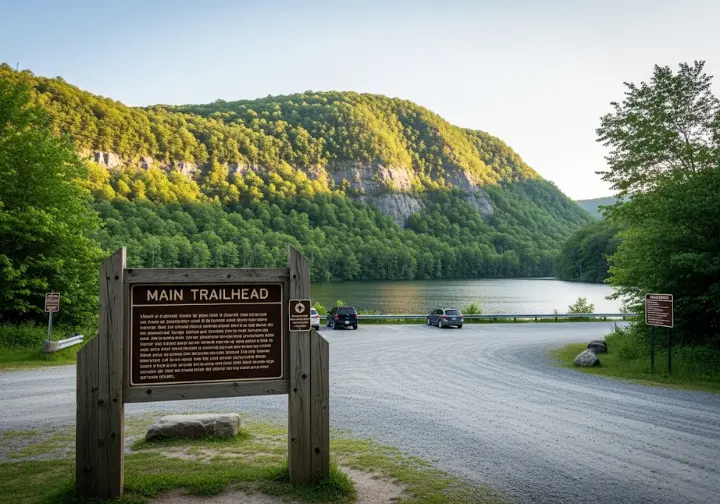
The location of Giuffrida Park is in a residential area of Meriden, Connecticut, with the official address being 800 Westfield Road, Meriden, CT 06450. Using these specific GPS coordinates (41.562115, -72.762339) will lead you directly to the entrance, which is conveniently accessible from major state highways like I-91 and the Merritt Parkway (Route 15). Consulting the official City of Meriden facility details before you go is always a good practice.
Upon arrival, you will find a single, unpaved parking lot situated right next to Crescent Lake. This is the primary and only designated parking area, serving as the main trailhead for all hiking loops. The lot is medium-sized, with space for approximately 15-20 vehicles. Due to the park’s popularity, especially on weekends, it fills up quickly. Arriving early is your best strategy to secure a spot and get a jump on your hike. Knowing the essentials for a successful day hike ensures you’re prepared from the moment you park.
| Feature | Details |
|---|---|
| Address | 800 Westfield Rd, Meriden, CT 06450 |
| GPS Coordinates | 41.562115, -72.762339 |
| Cost | Free |
| Hours | Sunrise to 30 minutes after sunset |
| Key Activities | Hiking, Trail Running, Picnicking, Biking |
| Dogs Permitted? | Yes, on leash at all times |
| Swimming Permitted? | No, strictly prohibited |
Hours, Fees & Official Park Rules
The park is open to the public year-round from sunrise until a half-hour after sundown, and there is no entrance fee, making it a wonderfully accessible outdoor destination. The most critical rule to understand is that swimming is strictly prohibited in Crescent Lake, also known as Bradley Hubbard Reservoir. This is because the lake serves as a reserve water supply for the City of Meriden, and this regulation is in place to protect its quality, as noted in the city-managed trail systems brochure.
Other activities are also prohibited to preserve the park’s natural state and ensure visitor safety. These include boating, rock climbing, consuming alcohol, and fishing without a special city-issued license. These rules are detailed in the City of Meriden’s municipal code. Dogs are welcome but must be kept on a leash at all times. Adhering to these simple rules is one of the fundamental tips for beginner hikers and ensures the park remains a pristine resource for everyone.
The Acreage Question: Clarifying the Park’s True Size
When researching the park, you will encounter conflicting information about its size—some sources list 98 acres, while others claim 598. This isn’t an error but reflects different boundary definitions. The 98-acre figure refers to the core property owned by the City of Meriden, which immediately surrounds the parking area and Crescent Lake. This is the formally designated park land according to the general rules for Meriden parks.
For any hiker, the functionally relevant size is the much larger 598 acres. This area encompasses the entire recreational landscape accessible from the trailhead, including the extensive trail systems on Lamentation Mountain and Chauncey Peak, which are part of the greater Metacomet Ridge system. The park’s 24.8 miles of trails confirm that the hiker’s experience extends far beyond the core 98 acres, offering a vast area to explore.
Which Trail is Right For You? A Comparative Guide
Eliminate “trail choice paralysis” with a clear, side-by-side comparison of the park’s main hiking loops. With curated recommendations, you can easily select the perfect hike based on your time, fitness level, and desired experience.
Comparing the Core Hiking Loops
Giuffrida Park offers three primary hiking experiences with distinct characteristics. You can choose a strenuous ridge walk with dramatic views, a longer and less-crowded ridge hike, or a peaceful, flat lakeside stroll. The main trails are part of the Blue-Blazed Hiking Trail system, maintained by the Connecticut Forest & Park Association. The Chauncey Peak Loop is the most popular choice, famous for its steep climb and rewarding panoramic views overlooking Crescent Lake and the nearby quarry. It’s ideal for those seeking a challenging workout with a big scenic payoff.
The Lamentation Mountain Loop provides a longer, more immersive hike with multiple overlooks and significantly fewer people, making it the best option for hikers looking for solitude. In contrast, the Crescent Lake Loop is a flat, easy, and shaded walk around the reservoir, perfect for families, beginner hikers, or anyone looking for a relaxing nature walk. Choosing the right trail is the first step in mastering the art of hiking pace and enjoying your day.
Ragged Mountain Natural Area: Trail Comparison
Explore the diverse trails of Ragged Mountain Natural Area, from easy lake loops to challenging ridge hikes, and find your perfect adventure.
Best For…
A peaceful, flat stroll with families, children, and beginner hikers.
Est. Time
30-40 min
Elevation Gain
Flat
Best For…
Hikers seeking dramatic, panoramic cliff-top views and a short but steep, rewarding workout.
Est. Time
1-2 hours
Elevation Gain
~344 ft
Best For…
A longer, more immersive hike with multiple overlooks and fewer crowds.
Est. Time
2-3 hours
Elevation Gain
~750 ft
The Trail System In-Depth: Your Hiking Guide
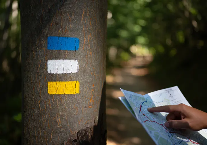
Dive into the details of each major trail, with route descriptions, key statistics like length and difficulty, and insider tips to help you navigate the park’s blue, white, red, and yellow-blazed paths with confidence.
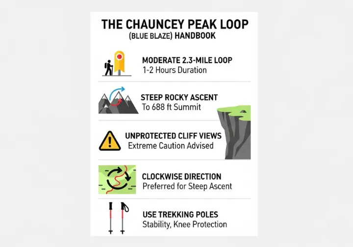
The Chauncey Peak Loop (Blue Blaze)
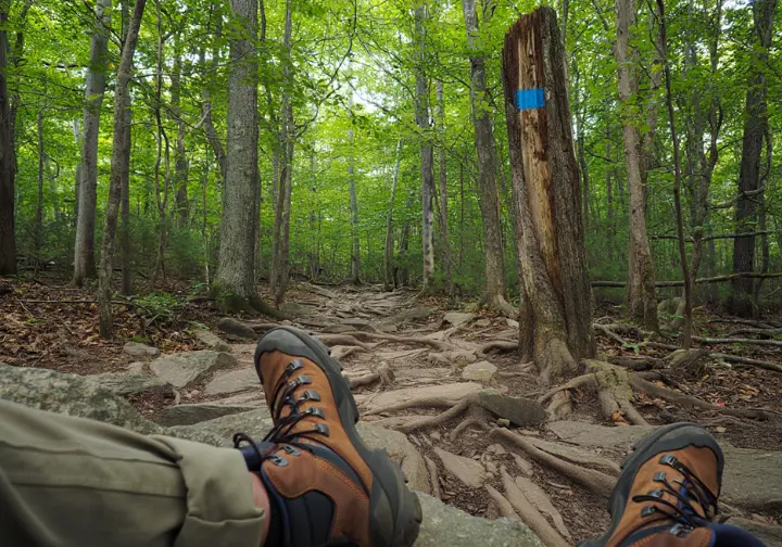
This is the park’s signature hike, a moderately difficult 2.3-mile loop that typically takes 1-2 hours to complete. This blue trail is marked with blue blazes and is part of the larger New England National Scenic Trail, which has an official guide from the New England Trail organization. The hike involves a steep and rocky ascent to the summit of Chauncey Peak (688 ft), where you are rewarded with spectacular, unprotected cliff-top views of Crescent Lake. Extreme caution is advised near the cliff edges, especially with children or dogs.
Most hikers prefer a clockwise direction, tackling the steepest part as an ascent. The descent, which is well-documented on Wikipedia, was rerouted around 2017 and now features a series of well-constructed rock switchbacks that make the journey down safer and more sustainable. Given the steep and rocky terrain, using trekking poles for added stability is highly recommended to protect your knees and maintain balance.
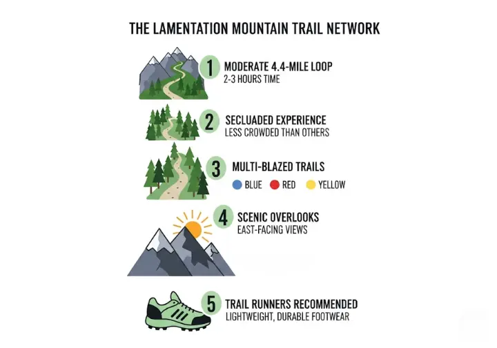
The Lamentation Mountain Trails (Blue, Red & Yellow)
This network of trails on the western side of the park offers a longer, moderately difficult hike of about 4.4 miles, taking roughly 2-3 hours. It provides a more secluded experience compared to the popular Chauncey Peak trail, with detailed information on Lamentation Mountain available for context. The main path is the blue-blazed Mattabesett Trail, which ascends to the 720-foot summit of Lamentation Mountain. The red and yellow-blazed trails serve as connectors, allowing hikers to create various loop options through the forest.
Along the ridgeline, you’ll find several scenic overlooks with views facing east. This trail system also includes a primitive tenting site designated for through-hikers on the New England National Scenic Trail. Navigating the different colored blazes is made easy with a detailed trail map from the Meriden Land Trust. The longer distance and varied terrain make lightweight and durable trail runners for rocky terrain an excellent footwear choice.
The Crescent Lake Loop (White Blaze)
For those seeking a gentle and peaceful experience, the Crescent Lake Loop is the perfect choice. This is an easy, 1.5-mile trail that is almost entirely flat and can be completed in about 30-40 minutes. The trail, marked with white blazes, encircles the beautiful Crescent Lake, offering serene water views throughout the walk. It follows a wide, well-maintained path that is suitable for all ages and fitness levels. This path is also part of the trail system listed in the state-level trail database.
This loop is the ideal option for families with small children, beginner hikers, or those looking for a relaxing cool-down after tackling one of the more strenuous ridge hikes. It’s also a great choice for trail running. Because it’s an easy walk on a relatively smooth surface, heavy-duty hiking boots are not necessary; a pair of comfortable and supportive walking shoes is perfectly adequate for this lovely stroll.
Safety & Responsibility on the Trails
Following crucial advice ensures your hike is not only enjoyable but also safe and low-impact. It covers specific hazards found in the park and details how to apply “Leave No Trace” ethics to the unique and fragile traprock ridge ecosystem.
Key Hazards: Cliffs, Terrain, and Wildlife
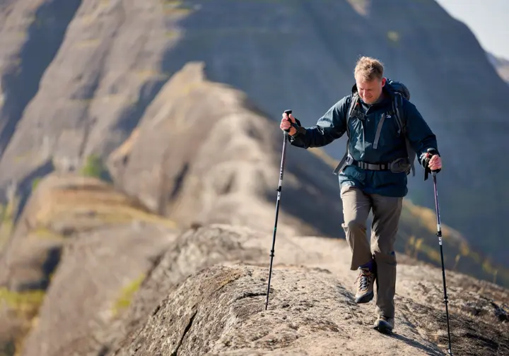
The single greatest hazard in Giuffrida Park is the presence of high, exposed cliff edges along the ridges of Chauncey Peak and Lamentation Mountain. These vertical drop-offs are unfenced, requiring extreme caution at all times, a fact highlighted in the alternate trail brochure from the SCRCOG. The terrain in Giuffrida Park is defined by its extremely rocky and uneven ridges, with many loose rocks and exposed tree roots that demand constant attention to your footing. Wearing sturdy hiking boots with good ankle support is strongly recommended over sneakers.
While not aggressive, the area is home to venomous snakes, including timber rattlesnakes and copperheads, which enjoy basking on the sun-exposed traprock ridges. Be aware of your surroundings, watch where you step, and never attempt to handle a snake. Wearing specialized gaiters for snake protection can offer an added layer of security and peace of mind on the trail.
Leave No Trace on the Traprock Ridges
The traprock ridge ecosystem is unique and fragile, making responsible hiking practices essential. Applying the seven Leave No Trace principles here requires special attention to the environment. The most important principle at Giuffrida Park is to “Travel on Durable Surfaces.” This means staying on the established trail and walking on the solid rock whenever possible, as the thin soil and delicate lichen communities in the crevices are extremely vulnerable to damage from foot traffic.
Be sure to pack out everything you pack in, including all food scraps like apple cores and orange peels, as there are no trash receptacles on the trails. Respect wildlife by observing from a distance and leave what you find, allowing others to enjoy the natural beauty. Following this guidance from the National Park Service is key. For those looking to deepen their commitment, mastering outdoor ethics is a rewarding journey.
Beyond the Hike: The Story of Giuffrida Park
To fully appreciate your hike, it helps to understand the story of the landscape itself. Delve into the park’s history, from the inspiring civic leader it was named for to the dramatic volcanic origins of the ridges you’ll be climbing.
The Park’s Namesake: Dr. Francis Giuffrida
The park was established in 1967 and named in memory of Dr. Francis Giuffrida, a beloved local surgeon and decorated World War II veteran who had passed away the previous year. He was an incredibly active and respected figure in the Meriden community, known for his compassion as a physician and his tireless dedication to civic leadership.
Dr. Francis Giuffrida was deeply involved with local youth programs, serving as a team physician for high school sports teams and working with the Boy Scouts. For his extensive community contributions and distinguished service, he was posthumously inducted into the Meriden Hall of Fame in 2011, cementing his legacy in the city’s history and providing a meaningful name for this beautiful public land.
The Geology of the Metacomet Ridge
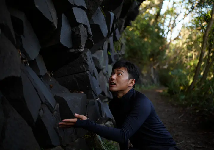
The dramatic ridges of Chauncey Peak and Lamentation Mountain are part of a much larger geological formation known as the Metacomet Ridge. This linear ridge of volcanic rock stretches over 100 miles from Long Island Sound up through Connecticut and Massachusetts. The hard, dark rock that forms the cliffs is called traprock, or basalt, and was formed around 200 million years ago from massive lava flows, a topic explored in this research paper on regional geology.
This rock is much more resistant to erosion than the surrounding sandstone, which is why it has remained as high ridges while the land around it wore away. This unique geology creates special microclimates—hot, dry cliff faces and cool, moist ravines—that support rare plant communities and serve as a major migration corridor for raptors. Understanding this deep history adds a rich layer to the hiking experience.
Conclusion
Doctor Francis Giuffrida Park offers a surprisingly diverse and dramatic hiking experience in central Connecticut, with options suitable for every skill level. This single, comprehensive resource empowers you to choose the right trail, understand the rules, and hike with confidence. The most rewarding visit comes from understanding the park’s unique landscape and committing to safe, responsible hiking practices to protect it. By preparing properly and respecting the environment, you can fully enjoy the stunning views and serene trails this local treasure has to offer.
Leave a comment below to share your favorite Giuffrida Park trail or ask any questions you still have!
Frequently Asked Questions about Hiking Giuffrida Park
How long are the trails at Giuffrida Park?
The park features three main loops: the easy Crescent Lake Loop (1.5 miles), the moderate Chauncey Peak Loop (2.3 miles), and the moderate Lamentation Mountain Loop (4.4 miles). The total trail network is much larger, approximately 24.8 miles, connecting to the regional New England Trail.
Can you swim in Crescent Lake at Giuffrida Park?
No, swimming is strictly prohibited. Crescent Lake is a reserve public water supply for the City of Meriden, and this rule is in place to protect the water quality. Boating and fishing (without a special permit) are also not allowed.
Are dogs allowed at Giuffrida Park?
Yes, dogs are permitted in the park, but they must be kept on a leash at all times. Owners are responsible for cleaning up after their pets, and dogs are not allowed in the water for safety and water quality reasons.
Who was Dr. Francis Giuffrida?
Dr. Francis Giuffrida was a beloved local surgeon, decorated WWII veteran, and community leader in Meriden. The park was named in his memory in 1967 to honor his extensive contributions to the city, particularly his volunteer work with local youth sports.
Risk Disclaimer: Hiking, trekking, backpacking, and all related outdoor activities involve inherent risks which may result in serious injury, illness, or death. The information provided on The Hiking Tribe is for educational and informational purposes only. While we strive for accuracy, information on trails, gear, techniques, and safety is not a substitute for your own best judgment and thorough preparation. Trail conditions, weather, and other environmental factors change rapidly and may differ from what is described on this site. Always check with official sources like park services for the most current alerts and conditions. Never undertake a hike beyond your abilities and always be prepared for the unexpected. By using this website, you agree that you are solely responsible for your own safety. Any reliance you place on our content is strictly at your own risk, and you assume all liability for your actions and decisions in the outdoors. The Hiking Tribe and its authors will not be held liable for any injury, damage, or loss sustained in connection with the use of the information herein.
Affiliate Disclosure: We are a participant in the Amazon Services LLC Associates Program, an affiliate advertising program designed to provide a means for us to earn advertising fees by advertising and linking to Amazon.com. As an Amazon Associate, we earn from qualifying purchases. We also participate in other affiliate programs and may receive a commission on products purchased through our links, at no extra cost to you. Additional terms are found in the terms of service.


