

In this article
Many seek out hiking trails Los Angeles offers, often heading straight for the famous Runyon Canyon. But LA’s hiking landscape is far richer and more diverse than just one popular spot. We’ll explore the extensive network managed by various agencies, delve into adventures within iconic Griffith Park, discover coastal views in the Santa Monica Mountains, and find escapes in the Angeles National Forest and local gems. We’ll also cover essential planning tips to navigate challenges like parking and crowds.
Ready to discover the best hiking trails Los Angeles has beyond the usual suspects? Let’s map out your next hike.
Unveiling LA’s Hiking Diversity
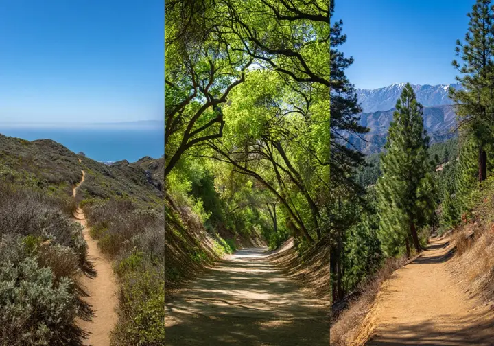
Los Angeles presents a surprisingly vast network of hiking trails, a sprawling map stretching from coastal mountains to urban parks. While Runyon Canyon draws attention, often leading to overcrowding, it merely hints at the numerous hiking trails available. Exploring beyond reveals a world managed by entities like the National Park Service, State Parks, USFS, and local bodies, offering diverse terrain but also common challenges like parking and crowds.
LA’s Extensive Trail Network
Los Angeles boasts hundreds of miles of hiking trails, far exceeding the confines of Runyon Canyon. These paths wind through the Santa Monica Mountains, Griffith Park, and the vast Angeles National Forest. You can find yourself traversing rugged peaks, coastal bluffs, or shaded canyons, with options suitable for every hiker, from beginner to seasoned trekker.
Management of these trails is a patchwork quilt. The National Park Service (NPS), California State Parks, U.S. Forest Service (USFS), and city or county departments share responsibility. For instance, Griffith Park is managed by the City of Los Angeles Department of Recreation and Parks. Knowing the managing agency is key, as rules can differ significantly.
The Santa Monica Mountains National Recreation Area (SMMNRA), overseen by the NPS, alone offers over 500 miles of trail options. This area showcases stunning coastal vistas and unique geological formations. Within this vast expanse, you’ll find different ecosystems and historical sites. Note that rules, like dog access, vary between NPS lands and adjacent State Parks like Malibu Creek State Park.
Griffith Park stands as one of the largest urban wilderness areas in the US. Its 4,210 acres contain over 53 miles of trails, fire roads, and bridle paths. Offering iconic views and varied terrain, from low canyons to peaks like Mt. Hollywood, its accessibility makes it popular but often crowded. You can learn more about its offerings by checking resources from organizations like Friends of Griffith Park.
For a more remote experience, the Angeles National Forest (ANF), managed by the USFS, covers over 650,000 acres in the San Gabriel Mountains. It features hundreds of miles of trails, high peaks, and seasonal waterfalls. Planning here often requires obtaining an Adventure Pass for parking, but the reward is a sense of solitude hard to find closer to the city.
Beyond these major players, numerous smaller regional parks offer hidden gems. Places like Eaton Canyon Natural Area, managed by LA County Parks, provide easier access and potentially fewer crowds. Exploring these local hiking spots Los Angeles offers requires awareness of their specific rules and facilities, adding another layer to the rich tapestry of LA hiking.
The Runyon Canyon Effect
Runyon Canyon’s celebrity status, fueled by easy access and pop culture mentions, creates a specific set of problems. Significant overcrowding and difficult parking often detract from the natural experience many seek. When Runyon Canyon closed temporarily, it underscored how reliant some hikers were on this single spot, highlighting the need for alternatives.
The sheer volume of alternative hikes listed in guides like HikingGuy and Modern Hiker shows a clear demand for options. These guides often categorize trails by features—waterfalls, views, difficulty—helping users navigate the choices. This abundance confirms LA’s richness but also the need for curation. What’s your biggest frustration with popular trails?
Parking scarcity and heavy foot traffic are the most common complaints across popular LA hiking trails. Limited lots, fees, confusing restrictions, and congested paths, especially on weekends, impact the experience. Even accessible alternatives often suffer similar issues, making logistics a primary concern for hikers.
Many easily reached alternatives, especially those mimicking Runyon’s appeal (like parts of Griffith Park or Eaton Canyon), frequently replicate its core issues. This “urban interface paradox” means finding true solitude might involve venturing deeper into places like the Angeles National Forest or choosing less famous trails. Some have even reported issues like car break-ins at busy trailheads, adding another layer of concern.
The real challenge isn’t a lack of hiking spots in LA, but sifting through them to find a trail matching specific needs: difficulty, scenery, location, dog policy, parking. Effective resources curate this information, providing details like length, elevation gain, and access specifics. Good guides like HikingGuy.com offer detailed trail profiles to help users make informed choices before hitting the trailhead.
Griffith Park Adventures
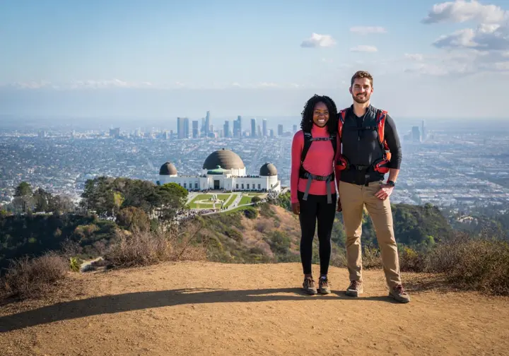
Griffith Park offers some of the most iconic Los Angeles experiences, with trails leading to the famous Observatory, unparalleled Hollywood Sign views, and historic sites like Bronson Canyon. While highly accessible, a visit demands strategic planning due to severe parking limitations and significant crowds, particularly near major attractions. Using shuttles or exploring quieter areas like Fern Dell can greatly improve the experience.
Iconic Griffith Park Trails
The Mt. Hollywood Trail, also known as the Charlie Turner Trail, delivers classic Griffith Park scenery. It culminates in 360-degree views encompassing the Observatory, downtown LA, and the Hollywood Sign from the park’s highest accessible peak. Access is often sought via the Griffith Observatory parking lot, which is notoriously crowded and expensive. Using the DASH shuttle is a far better alternative. This moderate, ~3-mile round trip trail hike permits leashed dogs.
For a steeper, more rugged hike, the path to the Wisdom Tree and Cahuenga Peak offers a rewarding challenge. It leads to a solitary tree that survived a fire and provides panoramic vistas, with options to extend towards the Hollywood Sign viewpoint. Parking is a significant hurdle; finding legal spots on Lake Hollywood Drive requires arriving very early. This challenging trail allows leashed dogs.
Hiking from Fern Dell up to the Griffith Observatory presents a shadier, often more pleasant approach than driving directly into the congestion. This moderate ~2-mile round trip starts near Trails Cafe. Street parking is available along Fern Dell Drive, offering access to the Observatory grounds and connecting paths. Leashed dogs are welcome in this lush part of the park, as detailed on the main Griffith Park page.
The Bronson Canyon trail is an easy, short walk (about 0.6 miles round trip) to the famous “Batcave.” This man-made tunnel featured in numerous films, including the 1960s Batman series. A dedicated parking lot at the end of Canyon Drive provides direct access. This spot offers a glimpse into Hollywood history, and leashed dogs are permitted.
General park rules are important to follow. Dogs must remain leashed throughout Griffith Park, and bicycles are prohibited on unpaved trails and fire roads. Trails officially close at sunset. Staying on marked paths is vital for safety and habitat protection, ensuring a responsible visit for all fellow hikers.
Griffith Park Logistics
Parking stands out as the biggest logistical headache in Griffith Park. Near the Observatory, expect paid parking and extreme congestion. The DASH Observatory shuttle from the Metro Red Line (Vermont/Sunset station) is strongly advised as the most straightforward access method. Parking near the Greek Theatre is free only when no events are scheduled, and still involves a walk or shuttle ride up.
Trailheads relying on street parking, like the Wisdom Tree hike access via Lake Hollywood Drive, fill incredibly quickly. Arriving very early and carefully checking residential parking signs is essential to avoid tickets. Consideration for local residents regarding noise and access is paramount. Remember that hiking requires planning beyond just the trail itself.
High visitor volume is standard throughout Griffith Park, especially on weekends and near landmarks like the Observatory and Hollywood Sign viewpoints. Expect crowded trails and plan accordingly. Choosing less popular routes or visiting during off-peak hours can lead to a quieter experience. Even the NPS acknowledges the park’s popularity.
Safety involves staying on marked paths, being aware of wildlife like coyotes and rattlesnakes, and managing heat exposure on trails with limited shade. Trails close at sunset, and carrying sufficient water is non-negotiable, particularly in warmer months. Following park rules contributes to a safer visit for everyone.
Park management uses strategies like paid parking and shuttle promotion to handle the crowds drawn by its accessibility and fame. For visitors, this means strategic planning is key. Using shuttles, visiting off-peak, or choosing less congested trailheads like Fern Dell helps mitigate frustration and allows enjoyment of this urban oasis. Understanding park operations helps manage expectations.
Santa Monica Mountain Hikes
The Santa Monica Mountains offer a stunning array of hiking experiences, from coastal canyons offering ocean breezes to inland peaks with panoramic views. This area is managed by a mix of NPS and State Parks, resulting in varied rules, especially concerning dogs and fees. Popular trails like Los Liones boast incredible vistas but face parking challenges and specific restrictions, demanding careful pre-trip planning using official agency sources.
Coastal Views and Canyons
The Los Liones Trail to Parker Mesa Overlook is a classic hike delivering spectacular coastal panoramas over Santa Monica Bay. Reaching the 1,525-foot viewpoint involves a moderately challenging trek of about 7.3 miles round trip with significant elevation gain. The trail begins in a lush canyon before climbing exposed fire roads. Parking along Los Liones Drive is free but highly competitive.
A critical detail for the Los Liones/Parker Mesa hike: dogs are generally NOT permitted on trails within Topanga State Park, which includes the main route to the overlook. Official State Park resources confirm this restriction, despite some confusion online. An exception applies only to a very short initial section near the Day Use area. Dog owners should opt for NPS-managed trails instead.
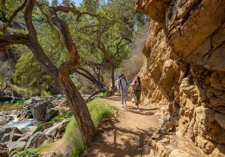
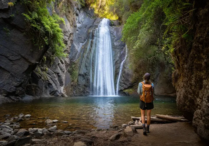
Solstice Canyon, managed by the NPS, offers a different experience. It features the ruins of the “Tropical Terrace” house and a seasonal 30-foot waterfall. The main trail is an easy 2-3 mile round trip, suitable for many hikers. More strenuous loops like the Rising Sun Trail provide ocean view opportunities. Leashed dogs are permitted on these NPS trails.
Parking at Solstice Canyon is extremely limited and fills rapidly, especially on weekends. Arriving early or carpooling is essential. The main lot is free but small; overflow parking along Corral Canyon Road requires careful adherence to posted signs. Checking the official Santa Monica Mountains NPS site for alerts before visiting is always a good idea.
The Temescal Canyon Loop, within Temescal Gateway Park (State Park land), is a moderate ~3.2-mile hike. It offers ocean views from the ridge and a seasonal waterfall in the canyon. Parking requires a fee in the main lot, or searching for limited free street spots. Similar to other State Park trails in the area, dogs are not permitted on this popular loop.
Movie History and Peaks
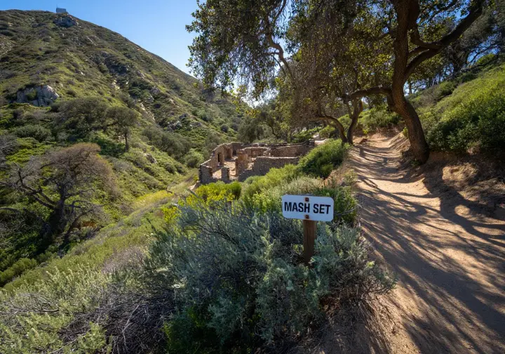
Malibu Creek State Park provides a popular, relatively easy hike (around 5 miles RT) to the preserved outdoor set of the M*A*S*H television show. The trail follows Crags Road alongside the creek, sometimes requiring a crossing if the seasonal bridge is out. Always check the park website for current bridge status and alerts before your hike.
Beyond the MASH site, Malibu Creek State Park boasts dramatic volcanic rock formations favored by climbers. You’ll also find the scenic Rock Pool (swimming allowed), Century Lake, and remnants of its past life as a movie ranch and country club. Many films were shot here, including Planet of the Apes. Access typically requires paying the State Park day-use fee.
It’s vital to know that dogs are NOT allowed on any dirt trails or fire roads within Malibu Creek State Park, including the MASH hike trail. They are restricted to developed areas like campgrounds and parking lots, per California State Park regulations. This rule is frequently misunderstood, so verify before bringing your pet.
Often cited as one of Southern California’s best hikes, the Sandstone Peak / Mishe Mokwa Trail loop leads to the highest point in the Santa Monica Mountains (~3,111 ft). Managed by the NPS, this challenging ~6-7 mile trail showcases stunning volcanic formations like Balanced Rock and offers panoramic ocean views. Leashed dogs are permitted on this rewarding trek.
Exploring the Santa Monica Mountains requires diligence. The mix of NPS and State Park management means differing rules (especially for dogs) and fees. Always confirm the managing agency and check their official website for current conditions and closures before setting out. Cell service is often unreliable, so carry maps and be prepared.
Angeles National Forest Escapes
The expansive Angeles National Forest offers a gateway to more rugged, wilderness-style hiking. Here you’ll find notable waterfalls like Eaton Canyon and Switzer Falls, historic sites such as Echo Mountain, and challenging routes like the Bridge to Nowhere. Hikers must prepare for hazards like creek crossings, obtain an Adventure Pass for parking at most trailheads, and always check official USFS alerts for closures and conditions.
Waterfall Quests ANF
Eaton Canyon Falls is an incredibly popular hike, leading to a picturesque 40-foot waterfall. Access is primarily via the Eaton Canyon Nature Center, an LA County Parks facility. The ~3.5-4 mile round trip trail starts easily but becomes rugged, demanding multiple stream crossings. The main parking lot is free but fills very quickly.
Safety at Eaton Canyon involves navigating slippery rocks during creek crossings and being aware of potential flash floods. Critically, hikers must NOT attempt to ascend beyond the lower falls into Upper Eaton Canyon. This area requires technical canyoneering skills and has been the site of numerous rescues. Leashed dogs are permitted on the lower falls trail.
Switzer Falls presents another popular waterfall hike (approx. 4 miles RT, moderate difficulty). Accessed from the Switzer Picnic Area off Angeles Crest Highway (SR 2), the trail follows the Arroyo Seco. It involves stream crossings and passes the ruins of the historic Switzer’s Camp resort en route to the 50-foot falls. Leashed dogs are allowed on this trail.
Parking at the Switzer Falls trailhead requires displaying a Forest Adventure Pass ($5/day or $30/year). The lot fills quickly. Due to its accessibility, some reports suggest caution regarding potential car break-ins; avoid leaving valuables visible. Always check the official ANF website for current alerts and pass requirements.
Waterfall flow throughout the Angeles National Forest is highly seasonal. It peaks in winter and spring after rains, potentially diminishing significantly or drying up completely in summer, fall, or drought years. Managing expectations based on recent weather is key. Creek crossings also become more challenging with higher water levels. Proper water filtration might be needed if planning longer trips.
Historic Peaks ANF
The Echo Mountain hike via the Sam Merrill Trail is a strenuous climb (~5.4 miles RT, ~1460+ ft gain). It leads to the fascinating ruins of Professor Lowe’s “White City” mountain resort from the 1890s. Hikers can explore hotel foundations, see remnants of the incline railway, and enjoy panoramic city views. Leashed dogs are permitted on this historic trek.
Accessing the Sam Merrill Trail means parking on residential streets near Lake Ave and Loma Alta Dr in Altadena. This area fills extremely quickly and demands respect for the neighborhood. An Adventure Pass isn’t needed for street parking here, but always check official ANF alerts for potential trail closures. The trail is mostly exposed, requiring sun protection.
The Bridge to Nowhere hike is a longer (~10 miles RT), moderate trek. It’s defined by numerous crossings of the East Fork San Gabriel River, with water depth varying seasonally. The destination is a dramatic, isolated concrete bridge, built for a road washed away in 1938, now a site for commercial bungee jumping. An Adventure Pass is required for parking at the trailhead near Azusa.
Hiking in the ANF generally requires obtaining a Forest Adventure Pass ($5/day, $30/year) for parking at most developed trailheads and picnic areas. Passes can be purchased online, at ranger stations, or local vendors. Failure to display one can lead to a citation. Always check requirements for your specific destination.
The ANF presents significant wilderness hazards. These include potentially dangerous creek crossings, steep terrain, rattlesnakes, and limited cell service. Frequent closures due to fire danger, weather, or post-fire recovery are common. It’s absolutely essential to check the official USFS Angeles National Forest website for alerts before any trip.
Local Gems Explored

Beyond the major mountain ranges and parks, numerous local parks offer excellent hiking alternatives. These often feature easier parking and fewer crowds than the headline destinations. Franklin Canyon provides secluded nature near Beverly Hills, Fryman Canyon offers Valley views, Kenneth Hahn boasts sweeping city panoramas, Baldwin Hills features challenging stairs, and Debs Park offers tranquil ponds in Northeast LA.
Accessible Nature Loops
Franklin Canyon Park offers a surprisingly secluded escape nestled between Beverly Hills and the San Fernando Valley. It features easy trails like the reservoir loop, great for birding, and the more challenging Hastain Trail. Its history includes providing the backdrop for “The Andy Griffith Show” opening credits. A significant advantage is the free parking available within the park.
Fryman Canyon Park, connecting to Wilacre Park, provides a popular ~3-mile loop known as the Betty B. Dearing Trail. It offers good San Fernando Valley views and is accessible from Studio City. The trail includes shaded sections and passes the TreePeople headquarters, which has water fountains. Parking is available in a lot at the Wilacre Park entrance, though a fee may apply.
Ernest E. Debs Regional Park in Montecito Heights is a tranquil 300-acre nature reserve. It features hiking trails like the easy Wild Mustard Loop (~1.7 miles). Its central feature, Debs Pond, makes it a fine spot for birdwatching, offering a peaceful escape within Northeast LA. Leashed dogs are permitted on these trails.
These local parks often present simpler logistics compared to Griffith Park or the SMM. Free parking (Franklin Canyon) or potentially less impacted lots (Debs, Fryman) can reduce pre-hike stress. Their accessibility makes them great options for a shorter hike or family outings, providing valuable green space close to urban areas.
Many of these parks also connect to larger trail networks, opening possibilities for longer hikes. Franklin Canyon, for instance, links to Wilacre, Fryman, and Coldwater Canyon trails. This creates opportunities for extended exploration within the eastern Santa Monica Mountains. Checking park maps can reveal these useful connections for the ambitious hiker.
Unique City Vistas
Kenneth Hahn State Recreation Area, located in the Baldwin Hills, offers exceptional panoramic views. From its upper ridge trails (~2-mile loop), vistas stretch from the ocean to Downtown LA and the San Gabriel Mountains. The park also features Gwen Moore Lake, Japanese Gardens, and numerous picnic areas, making it a versatile urban open space. Parking typically requires a State Park day-use fee.
Baldwin Hills Scenic Overlook provides a unique, intense workout via its steep staircase – 282 steps ascending the hillside in Culver City. The summit offers commanding north-facing views of the LA basin, Century City, and the Santa Monica Mountains. Gentler paths are also available for ascent. It’s a popular spot for fitness enthusiasts.
Parking at Baldwin Hills Scenic Overlook involves a choice: free street parking along Jefferson Boulevard at the base, or a paid lot at the summit via Hetzler Road. Importantly, as a California State Park, dogs are NOT allowed here, including on the stairs or trails. Always check the official State Parks site for current fees and rules.
These elevated local parks offer alternative perspectives on the city compared to the more famous viewpoints in Griffith Park or the Santa Monica Mountains. They can often be less crowded and provide unique vantages, showcasing the vastness of the LA basin from different angles. Have you discovered a favorite local viewpoint?
The presence of amenities like picnic areas (Kenneth Hahn), gardens (Kenneth Hahn), nature centers (Franklin Canyon), or unique features like the stairs (Baldwin Hills) adds appeal beyond just hiking. These parks serve as valuable community resources, offering recreation and nature close to home.
Essential Hike Planning

Successfully hiking in LA means navigating logistical hurdles, primarily parking and crowds. Strategies like arriving early and using shuttles can make a difference. Safety is paramount, demanding preparation for heat, rattlesnakes, poison oak, and varied terrain. Diligently checking official agency websites for current trail conditions, closures, and required passes like the ANF Adventure Pass is non-negotiable for any hike.
Mastering LA Trail Parking
Parking scarcity is a defining characteristic at popular LA trailheads. Places like Griffith Observatory, Solstice Canyon, Eaton Canyon, and Echo Mountain access points see lots fill extremely early, especially on weekends. Arriving before 8 am is often necessary to secure a spot. Choosing to hike on a weekday can offer significant relief from parking stress.
Parking costs fluctuate widely. You might find free street parking (if you’re lucky and legal), face hourly meters (like $10/hr at Griffith Observatory), or pay daily fees ($12+ at State Parks like Malibu Creek). The USFS Adventure Pass ($5/day, $30/yr) is mandatory for parking at most developed sites within the Angeles National Forest. Factor these costs into your planning.
Navigating parking restrictions in residential areas near trailheads (e.g., Lake Ave for Echo Mountain) requires careful attention to signs to avoid tickets or towing. Respecting residents by minimizing noise and not blocking driveways is essential. Understanding where passes are required (ANF lots) versus where they aren’t (street parking outside ANF) prevents confusion.
Alternative transportation can be a game-changer. The DASH Observatory shuttle for Griffith Park is highly recommended to bypass parking headaches entirely. Carpooling is strongly advised for areas with notoriously limited parking, such as Solstice Canyon. Think ahead about how you’ll get to the trailhead.
Mitigating potential car break-ins, which have been reported at some accessible ANF trailheads, involves never leaving valuables visible. Remove all items of value before leaving your vehicle. It’s a simple precaution that can prevent a frustrating end to your hike.
Avoiding Trail Crowds
Timing is your best ally against crowds. Hiking very early (before 8 or 9 am) or on weekdays dramatically reduces the number of people on popular trails. Choosing less famous routes or longer hikes that naturally disperse people also helps achieve more solitude. Even popular spots can be quieter if timed right.
Seasonal factors influence crowds. Popular waterfall hikes will be busiest after rains. Wildflower hotspots attract large numbers during peak bloom weekends. While resources like the Theodore Payne Wildflower Hotline can offer insights, anticipate crowds at well-known locations during prime conditions. Patience is often required.
Accept that easily accessible trails with major attractions – Eaton Canyon Falls, Echo Mountain ruins, Griffith Observatory views – will likely always have substantial foot traffic, especially in good weather. Adjusting expectations or actively seeking out truly “hidden gem” trails might be necessary if peace and quiet are your top priority. Some trails are just inherently popular.
Using official park resources can sometimes yield information on peak times or suggest less-visited areas within larger parks. Ranger stations or visitor centers, like those in the Santa Monica Mountains National Recreation Area, might offer advice on finding quieter trails if you ask.
Consider exploring sections of longer trail systems rather than just the main destination points. Often, hiking further along a trail beyond the primary waterfall or viewpoint leads to significantly fewer people. Going the extra mile can literally mean more solitude.
LA Hiking Safety Essentials
Heat and sun exposure pose major risks on many LA trails, particularly those lacking shade. Hike during cooler parts of the day, wear sun protection (hat, sunscreen, UPF clothing), and carry ample water – at least 1-2 quarts per hour in hot conditions. Knowing the signs of heat exhaustion is vital.
Rattlesnakes are common, especially from April to October. Be vigilant, watch where you step and place your hands, wear sturdy hiking shoes or boots and long pants, stay on trails, and keep dogs leashed. If you encounter one, stop, back away slowly, and give it space. Call 911 immediately for any bite.
Poison oak, recognizable by its three-leaf clusters, is prevalent. Learn to identify it, wear long sleeves/pants in brushy areas, and wash skin and clothing thoroughly after suspected contact. Staying on marked trails helps minimize exposure. Awareness is your best defense against this itchy nuisance.
Terrain hazards include slippery creek crossings (especially after rain), steep or loose trails, and the critical danger of attempting technical routes like Upper Eaton Canyon without proper skills and gear. Use caution, wear appropriate footwear, and stay on marked paths. Be aware of flash flood risks in canyons.
Navigation requires carrying maps (physical or offline digital), as cell service is unreliable in many canyons and remote areas. Inform someone of your hiking plans and expected return time. Consider a satellite communicator for remote hikes. Don’t rely solely on your phone. Pack the essentials for navigation and safety.
Critically, always check official agency websites (NPS, USFS, State Parks, County/City Parks) for the latest alerts, closures (due to fire, flood, snow, maintenance), and conditions before every single hike. Conditions change rapidly, and relying on outdated information is unsafe. This step is non-negotiable.
Understanding LA’s Trails
Appreciating LA hikes involves more than just the physical trek. Understanding their historical context – from Indigenous paths and Spanish ranchos to early resorts and movie sets – adds depth. Recognizing the unique Mediterranean ecology (chaparral, oaks, wildlife) enhances the connection to place. Planning should also account for distinct seasons, always checking conditions beforehand.
History Beneath Your Boots
Many LA trails follow ancient routes used by Indigenous peoples like the Chumash and Tongva for millennia. These paths connected coastal areas to inland valleys for trade and resource gathering. Sites like the Satwiwa Native American Indian Culture Center in the Santa Monica Mountains reflect this deep heritage. Recognizing this history enriches the hiking experience.
The era of Spanish Ranchos and later American settlement left its mark. Remnants like the Sepulveda Adobe foundations in Malibu Creek State Park recall early agricultural life. These historical layers are woven into the fabric of the landscape, telling stories of transformation and adaptation across the hills and canyons.
Ambitious early 20th-century recreational developments created destinations that are now historic hiking sites. The Mount Lowe Railway leading to Echo Mountain’s “White City” resort left fascinating ruins. Exploring these remnants offers a tangible link to LA’s early tourism boom. Switzer’s Camp in the ANF is another example of this era.
Hollywood famously used the local mountains as backlots. Malibu Creek State Park, formerly Fox Ranch, hosted filming for M*A*S*H and Planet of the Apes, with set pieces still visible. Bronson Canyon’s “Batcave,” tied to early quarrying, is another iconic filming location accessible via an easy hike.
Understanding these layers—Indigenous presence, rancho life, resort development, Hollywood’s golden age—transforms trails from mere paths into corridors through time. Recognizing the stories embedded in the landscape adds context and appreciation for the region’s rich past during your scenic adventure.
Local Ecology Insights
LA’s trails wind through a Mediterranean ecosystem, defined by hot, dry summers and mild, wet winters. This climate supports distinct plant communities like drought-tolerant chaparral and coastal sage scrub. Oak woodlands thrive in cooler, moister areas, while riparian corridors host sycamores and alders. Recognizing these plant communities enhances understanding.
Wildlife adapted to this environment includes coyotes, mule deer, bobcats, and numerous bird species. Mountain lions exist but are rarely seen. Rattlesnakes are a common and vital part of the ecosystem, requiring hiker vigilance. Feeding wildlife is prohibited to protect both animals and people. Respecting wildlife space is crucial.
Wildfire is a natural, recurring force that shapes the chaparral-dominated landscape. It influences vegetation patterns and poses risks. Post-fire recovery periods often lead to trail closures due to erosion or hazardous conditions. Understanding fire’s role provides ecological context for the landscapes you traverse.
Water availability fluctuates dramatically with rainfall, impacting stream flows, waterfall intensity, and plant life. Drought cycles stress the ecosystem. Conversely, wet winters can bring lush growth and vibrant wildflower displays, transforming the hills. This variability is key to the region’s ecology.
Conservation efforts focus on protecting biodiversity, managing invasive species, and restoring habitats within these valuable natural lands adjacent to a major metropolis. Responsible hiking practices, like staying on trails and packing out trash, directly support these efforts. Protecting these areas is a shared responsibility.
Best Seasons for Hiking
Spring (late March-May) often brings spectacular wildflower displays, especially after wet winters. Hillsides can erupt in color. Resources like the Theodore Payne Foundation Wildflower Hotline can guide you to locations like Antelope Valley or Malibu Canyon. Remember to stay on trails and admire flowers without picking them.
Winter and early Spring provide the best conditions for viewing waterfalls. Flows are strongest following seasonal rains. Trails like Eaton Canyon, Switzer Falls, and Solstice Canyon become popular destinations during this time. Be prepared for potentially challenging, slippery creek crossings. Water levels can change quickly.
Summer (June-September) demands careful planning due to high heat. Prioritize early morning or late evening hikes. Choose trails with ample shade, such as those in deep canyons or on north-facing slopes like Fern Dell. Carry extra water and use robust sun protection. Coastal trails might offer some relief due to ocean breezes.
Fall and Winter frequently offer the most comfortable hiking temperatures, making them ideal for longer or more strenuous routes. Air clarity can be exceptional after rain, providing stunning long-distance views. Be mindful of shorter daylight hours and potential snow or ice at higher elevations in the Angeles National Forest. Check conditions before heading to higher altitudes.
Regardless of the season, always check current trail conditions and alerts on official agency websites before heading out. Weather patterns, fire activity, and maintenance needs can lead to closures or hazardous conditions year-round. This proactive check is essential for safety. What’s your favorite season for hiking?
Conclusion: Explore LA Trails
Los Angeles offers a truly vast and varied network of hiking trails, extending far beyond the well-trodden path of Runyon Canyon. From Griffith Park’s urban wilderness to the coastal Santa Monica Mountains, the rugged Angeles National Forest, and accessible local parks, there are experiences for every skill level. The main challenges remain logistics – parking and crowds – and safety hazards like heat and rattlesnakes, demanding thoughtful planning. Understanding the patchwork of land management agencies and their specific rules, especially regarding dogs and fees, is key to a smooth hike.
Before your next Los Angeles hike, identify the specific trail and its managing agency (NPS, USFS, State Park, City, County). Visit the official agency website to check for current alerts, closures, conditions, fees (including ANF Adventure Pass needs), and regulations (like dog policies). Plan your timing strategically – arrive early or hike weekdays to mitigate parking and crowd issues.
Use the information here and the official resources linked throughout to select trails matching your desired experience – whether you seek sweeping views, waterfalls, history, solitude, or a specific difficulty level. Pack the essentials appropriate for the trail and season (water, sun protection, map, sturdy hiking shoes). Let someone know your plans. Now, go discover the incredible natural beauty and rich history waiting on the hiking trails Los Angeles provides.
Frequently Asked Questions
What is the most popular hiking trail in Los Angeles? >
Are dogs allowed on hiking trails in Los Angeles? >
Do I need a pass to hike in Los Angeles? >
What should I bring on a day hike in Los Angeles? >
We are a participant in the Amazon Services LLC Associates Program, an affiliate advertising program designed to provide a means for sites to earn advertising fees by advertising and linking to Amazon.com. As an Amazon Associate I earn from qualifying purchases. We also participate in other affiliate programs. The information provided on this website is provided for entertainment purposes only. We make no representations or warranties of any kind, expressed or implied, about the completeness, accuracy, adequacy, legality, usefulness, reliability, suitability, or availability of the information, or about anything else. Any reliance you place on the information is therefore strictly at your own risk. Additional terms are found in the terms of service.


