

In this article
You’ve seen the photos, read the breathless trip reports, and now a dozen bucket-list hikes are swirling in your head. But faced with endless, subjective descriptions, choosing the right multi-day hike can feel overwhelming. One person’s “gentle climb” is another’s vertical suffer-fest. This guide provides a data-driven approach to decode trail comparison tables, empowering every type of hiker—from casual hikers to aspiring thru-hikers—to systematically select the perfect adventure for their specific goals and abilities.
You will learn to deconstruct any trail into standardized, comparable metrics, moving beyond vague descriptions to hard data. You’ll discover how to create a personalized “Hiker Profile” to weigh trail attributes against what truly matters to you. We’ll see the framework in action with a case study comparing three iconic trails and, finally, translate that analysis into a concrete plan covering permits, logistics, and trail-specific gear.
What Are the Key Metrics in a Trail Comparison Table?

To compare trails effectively, you first need to break them down into their essential components—the “anatomy” of a hike. These data points are the building blocks of any good analysis. We can group them into quantitative metrics (the hard numbers), qualitative attributes (the character), and logistical factors (the operational realities).
What are the core quantitative metrics?
These are the objective, foundational numbers that define a trail’s physical demands and scope. They form the bedrock of any serious comparison, allowing you to accurately measure the distance and effort required for your hike.
- Distance & Elevation Gain: These two metrics are inseparable. Distance (miles/km) sets the overall length of the journey, but the Total Elevation Gain/Loss is the true currency of effort. A flat 50-mile trail across flat terrain is a world apart from a 30-mile trail with 15,000 feet of elevation gain, which will demand far more from your body.
- Duration: The typical number of days hiking is a direct consequence of distance and elevation. It dictates the most critical logistical calculations for your trip, from how much food and fuel you must carry in your backpack to how you structure your daily mileage.
- Cost (Permits & Services): This covers the direct financial outlay. It includes everything from non-refundable lottery application fees and nightly campsite costs to mandatory shuttles or optional services like luggage transfers that can fundamentally change the experience.
- Steepness (Gain per Mile): This powerful derived metric (Total Elevation Gain / Total Distance) normalizes difficulty across trails of different lengths. It provides a better “apples-to-apples” comparison of how strenuous the climbing will feel, exposing the true character of the elevation change over the entire trail.
Understanding how land managers use this data is key. For example, the Shenandoah National Park’s hiking difficulty formula is a prime example of using quantitative data to create a rating. Once you have these numbers, you can begin transforming these metrics into a digital route plan using tools like CalTopo or Gaia GPS for detailed route mapping.
| Metric | What It Measures | Why It Matters for Planning |
|---|---|---|
| Distance | The total length of the trail in miles or kilometers. | Defines the overall scope and is a primary input for calculating duration and food needs. |
| Total Elevation Gain/Loss | The cumulative vertical feet or meters you will ascend and descend. | The single best indicator of physical exertion and muscular-skeletal stress. |
| Duration | The typical number of days required to complete the trail. | Dictates food, fuel, and permit logistics. Helps set a realistic daily pace. |
| Cost | The total financial expense for permits, fees, and required services. | Determines the budget for the trip and can be a significant barrier on popular routes. |
| Steepness (Gain/Mile) | A derived metric showing the average elevation gain per mile. | Normalizes difficulty; a high value indicates consistently steep terrain. |
How do you assess qualitative and logistical attributes?
While numbers tell much of the story, a trail’s character and operational requirements are just as important. These attributes define the experience and often present the biggest hurdles in planning a hike.
- Difficulty Rating: Labels like “Strenuous” or “Moderate” are highly subjective and lack a universal standard. A “strenuous” hike in a local park is not the same as a “strenuous” rating in the high Sierra. Treat this as a conclusion drawn from other data, not a primary metric itself.
- Scenery Type & Best Season: These define the hike’s aesthetic and its optimal weather window. Is it high-alpine granite, dense rainforest, or rolling moorlands? Will you be crossing high mountain passes or deep canyons? The “Best Season” is a critical safety factor, especially on routes like the Wonderland Trail, where snow can linger into late summer.
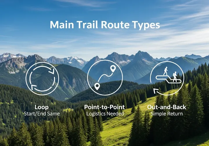
- Route Type & Permit System: The Route Type (Loop, Point-to-Point, Out-and-Back) is a primary logistical driver determining transportation to and from the trailhead. The Permit System is often the single greatest obstacle. Competitive lotteries for thru-hikes like the Pacific Crest Trail or John Muir Trail require expert planning months, or even a year, in advance.
- Accommodation, Water, and Resupply: These attributes define your gear and daily strategy. Accommodation (designated campsites, dispersed wild camping, or town inns) dictates your shelter system and pack weight. Water source reliability and resupply options determine the maximum number of days you can stay out between towns, a key concern for any long trail.
Official data sources like the page on Grand Teton National Park’s backcountry camping zones provide excellent, verifiable examples of these logistical attributes. Mastering these concepts is a key part of transitioning from simple day hikes to multi-day backpacking.
How Do You Personalize the Data with a Hiker Profile?

Collecting objective data is the first step. The real magic happens when you filter that data through the lens of your own goals, abilities, and desires. This is where you move from a generic spreadsheet to a personalized decision-making tool for your next hike.
Why is self-assessment more important than the raw data?
The value of any trail metric is dynamic and deeply personal. An attribute that is a benefit to one hiker, such as the luggage transfers available on the Camino de Santiago, is a distinct drawback to another seeking a more self-reliant wilderness experience. The goal is not to find the “best” trail in a vacuum, but the trail that is the optimal fit for you.
To move from data collection to interpretation, you need a structured way to define what you value most. Are you seeking a profound physical challenge, sublime scenery, deep solitude, or logistical comfort? This self-assessment turns a static table of facts into a dynamic decision-making tool tailored to your unique hiking identity, whether you’re planning your first thru-hike or a weekend trip.
The best trail emerges not from the data alone, but from the intersection of the data and a clear understanding of personal goals.
This process of trip planning self-assessment is a natural extension of identifying your motivations for hiking as a hobby in the first place.
How can you use the Hiker Profile Matrix to score trails?
The Hiker Profile Matrix is a simple tool to formalize this self-assessment. It turns your vague preferences into a quantitative weighting system, helping you create a personal “algorithm” for trail selection.
The matrix asks you to rate the importance of five value categories on a 1-5 scale: Physical Challenge, Scenic Beauty, Solitude & Remoteness, Comfort & Logistics, and Budget. To guide you, each category includes a core question. For “Physical Challenge,” ask yourself: “How important is it for me to feel physically pushed to my limits?” Your honest answer determines your score.
By completing the matrix, you create a personalized filter. You can then evaluate potential trails based on how well their attributes align with your highest-scoring priorities. This is a foundational step in preparing your mind, body, and budget for a major trek.
| Category | Rating (1-5) | Core Question |
|---|---|---|
| 1. Physical Challenge | [ ] | (How important is it for me to feel physically pushed to my limits?) |
| 2. Scenic Beauty | [ ] | (How important are dramatic, “five-star” views every day?) |
| 3. Solitude & Remoteness | [ ] | (How important is it to feel far from crowds and civilization?) |
| 4. Comfort & Logistics | [ ] | (How important are easy logistics, soft beds, and readily available services?) |
| 5. Budget | [ ] | (How important is it to minimize the overall cost of the trip?) |
How Does This Framework Apply to Real-World Trails?

Let’s put this theory into practice. By applying our data-driven framework to three iconic but vastly different multi-day hikes, we can see how different hiker profiles would interpret the same set of facts to arrive at different conclusions.
What does a master comparison table look like?
Our case study will compare three classic treks: the Teton Crest Trail (TCT) in Wyoming, the Wonderland Trail (WT) in Washington, and the West Highland Way (WHW) in Scotland. The first step is to build a master table, populating it with sourced data for each of our key metrics.
This table immediately highlights the stark differences. Notice the massive elevation gain of the Wonderland Trail compared to the others, or the radically different permit and accommodation systems. The WHW stands out as a classic self-guided adventure where you can travel at your own pace, while the TCT and WT are pure wilderness backpacking experiences. This data is corroborated by official sources, such as the NPS page on the Wonderland Trail’s highly competitive permit lottery.
| Metric | Teton Crest Trail (TCT) | Wonderland Trail (WT) | West Highland Way (WHW) |
|---|---|---|---|
| Distance | ~40 miles | ~93 miles | 96 miles |
| Elevation Gain | ~9,000 ft | ~25,000 ft | ~12,000 ft |
| Steepness (Gain/Mile) | ~225 ft/mile | ~269 ft/mile | ~125 ft/mile |
| Typical Duration | 4-6 days | 9-13 days | 7-8 days |
| Scenery Type | High-alpine granite peaks | Volcano, glaciers, rainforest | Rolling hills, lochs, moorland |
| Best Season | Aug – mid-Sep | Late Jul – mid-Sep | May – Sep |
| Permit System | Competitive Advance Reservation | Highly Competitive Lottery | None |
| Accommodation | Designated campsites | Designated campsites | Inns, B&Bs, Wild Camping |
| Support Services | None | None | Extensive luggage transfers |
How would different hiker profiles choose a trail?
Now, let’s see how different hikers, using their Hiker Profile Matrix scores, would analyze this table.
- The Endurance Challenger (High score on Physical Challenge): This hiker is immediately drawn to the Wonderland Trail. Its staggering 93-mile distance and 25,000+ feet of gain on challenging terrain represent the ultimate physical test. The logistical complexity of the permit and resupply plan is a feature, not a bug. The TCT would feel too short, and the WHW, with its lower steepness and support services, wouldn’t provide the desired rugged challenge.
- The Scenery-Seeker (High score on Scenic Beauty): This hiker might choose the Teton Crest Trail. While shorter, it offers a higher concentration of dramatic, high-alpine vistas per day. For someone prioritizing iconic mountain skylines above all else, the TCT’s constant, in-your-face views of the Grand Teton range are hard to beat.
- The Solitude-Craver (High score on Solitude): This hiker would likely eliminate the popular West Highland Way first. Their choice would be between the TCT and WT. They might lean toward the TCT but strategically plan for the shoulder season (early September) to avoid peak crowds and the chance of meeting many fellow thru-hikers, using the permit data to secure campsites in less-trafficked zones.
- The Comfort-Focused Trekker (High score on Comfort & Logistics): The choice is clear: the West Highland Way. It’s the only one of the three offering a comprehensive infrastructure of B&Bs, pub meals, and luggage transfers. For a hiker who wants to experience a beautiful landscape without the hardships of carrying a heavy pack and sleeping on the ground, the WHW is the perfect fit, similar to other multi-day hikes in Europe like the West Highland Way.
How Do You Translate Table Data into an Actionable Plan?
Analysis is worthless without action. The final step is to use the specific data points from your chosen trail’s column to build a concrete, non-negotiable plan for permits, logistics, and gear.
How does the trail’s permit system drive your planning timeline?
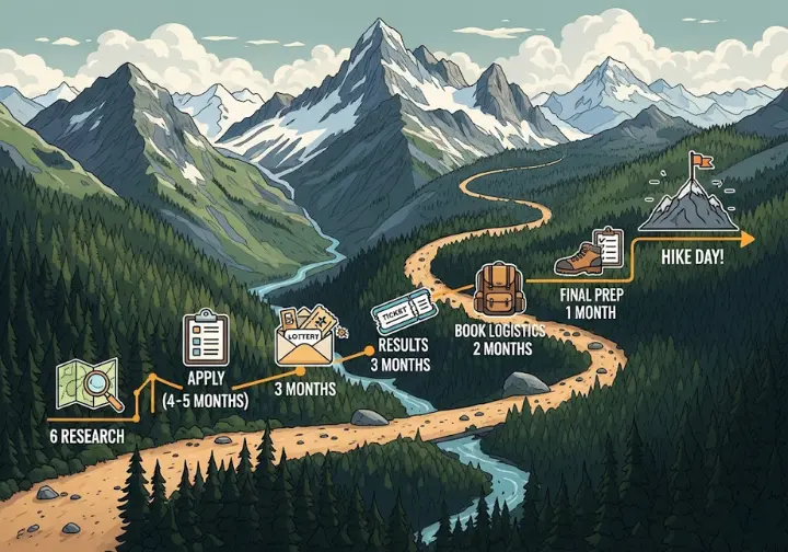
The “Permit System” entry in your table is the single most critical logistical driver. It dictates your entire planning calendar.
- Competitive Lottery (Wonderland Trail): Your plan must begin months in advance. You need to mark the exact application window (typically February-March for the WT) on your calendar and have a detailed itinerary ready. A contingency plan for a failed lottery is not optional; it’s essential, as trail managers receive applications from thousands of hikers.
- Advance Reservations (Teton Crest Trail): Your plan centers on a specific date and time. For the TCT, this is when reservations open on Recreation.gov. You must be online and ready to book your desired campsites the second they become available, as detailed on the Grand Teton’s advance backcountry permit reservations page.
- Wild Camping with Restrictions (West Highland Way): While no permit is needed for the trail itself, your plan must account for specific management zones (e.g., along Loch Lomond) that restrict wild camping from March to September. This requires pre-booking official campsites or planning an itinerary that bypasses these zones on the correct days.
Understanding this process is crucial for any popular route, and it’s a key skill when navigating the highly competitive Kalalau Trail permit system or any other in-demand trail.
How does the trail’s data dictate your gear selection?
A trail’s physical data and regulations have a direct, non-negotiable impact on your gear list. You don’t choose your gear in a vacuum; the trail chooses it for you.
- “Mandatory Bear Canisters” (Teton Crest Trail): This single regulation requires you to carry a specific, bulky piece of gear. A 2-3 pound bear canister not only adds weight but also demands a backpack with sufficient volume to carry it internally, influencing your choice of pack and potentially your pre-hike base weight.
- “Snow lingers into July / Ice Axe May Be Useful” (Wonderland Trail): This note in the data table is a critical safety warning. An early-season attempt requires not just microspikes and an ice axe, but also the proven skills to use them for self-arrest on steep, snowy traverses in mountainous terrain where a slip could be fatal.
- “Frequent Rain” (Mount Rainier/Wonderland Trail): The climate data dictates that your gear list must be built around a robust moisture management system. This means prioritizing high-quality hard-shell rain gear, pack liners, and potentially synthetic insulation, which retains warmth better than down when damp.
This reinforces the idea that data, not just vague labels, should drive preparedness, a concept supported by organizations like the Sierra Club in their Hike Rating System. Knowing when to carry traction is a skill, and it starts with understanding the difference and choosing between microspikes and crampons.
Conclusion
Choosing the right multi-day hike is a skill that can be learned and mastered. The key is to move beyond subjective stories to an objective, data-driven comparison of standardized metrics. By filtering this hard data through a personalized “Hiker Profile Matrix,” you can align a trail’s objective attributes with your own subjective priorities for challenge, scenery, solitude, and comfort. This process ensures a trail’s logistical data and physical demands directly inform your planning timeline and mandatory gear choices. Mastering this framework of inquiry and analysis will empower you to select more ambitious, successful, and personally rewarding adventures with confidence.
Frequently Asked Questions about Trail Comparison Tables
Is a trail’s “Difficulty Rating” a reliable metric?
A trail’s difficulty rating (e.g., “Strenuous”) is not very reliable on its own because there is no universal standard across different parks, organizations, or countries. It’s far more effective to look at the underlying quantitative data, like total elevation gain and especially steepness (gain per mile), to make your own assessment of the physical demands.
What is the single most important metric for planning?
For logistical planning, the “Permit System” is often the most critical metric. It dictates your entire timeline and can be the single biggest hurdle to successfully planning a trip on a popular trail. For physical planning and assessing effort, the “Total Elevation Gain” is arguably more important than distance, as it’s a much better indicator of the actual work required.
How do I find the data to build my own comparison table?
The best data sources for accurate information are official land manager websites (e.g., National Park Service, US Forest Service, or a national trail’s official association). These sites provide the most current and reliable information on permits, trail conditions, and regulations. Reputable guidebooks and high-authority niche hiking blogs that conduct a comprehensive survey or publish hiker survey data are also excellent sources for compiling metrics.
Can I use this method for planning day hikes?
Yes, this data-driven approach is perfectly suited for planning challenging day hikes. While some metrics like resupply and multi-day permits won’t apply, the core process is the same. Comparing data for the distance, elevation gain, steepness, and route type of several potential day hikes on local trails or even local forest paths is an excellent way to choose the best one for your available time, energy, and goals for the day.
Risk Disclaimer: Hiking, trekking, backpacking, and all related outdoor activities involve inherent risks which may result in serious injury, illness, or death. The information provided on The Hiking Tribe is for educational and informational purposes only. While we strive for accuracy, information on trails, gear, techniques, and safety is not a substitute for your own best judgment and thorough preparation. Trail conditions, weather, and other environmental factors change rapidly and may differ from what is described on this site. Always check with official sources like park services for the most current alerts and conditions. Never undertake a hike beyond your abilities and always be prepared for the unexpected. By using this website, you agree that you are solely responsible for your own safety. Any reliance you place on our content is strictly at your own risk, and you assume all liability for your actions and decisions in the outdoors. The Hiking Tribe and its authors will not be held liable for any injury, damage, or loss sustained in connection with the use of the information herein.
Affiliate Disclosure: We are a participant in the Amazon Services LLC Associates Program, an affiliate advertising program designed to provide a means for us to earn advertising fees by advertising and linking to Amazon.com. As an Amazon Associate, we earn from qualifying purchases. We also participate in other affiliate programs and may receive a commission on products purchased through our links, at no extra cost to you. Additional terms are found in the terms of service.


