

In this article
- Why is St. George a World-Class Hiking Destination?
- Which Hikes Should You Explore in Snow Canyon State Park?
- What are the Must-Do Trails in the Red Cliffs NCA?
- What Other Iconic Hikes are Near St. George?
- How Can You Deepen Your Hiking Knowledge?
- Conclusion
- Frequently Asked Questions about Hiking Near St. George
Poised at the convergence of three dramatic ecosystems, St. George, Utah, offers a landscape of staggering beauty and diversity for hikers. This guide moves beyond a simple list of hiking trails; it provides a deep analysis of 12 essential hikes, empowering you with the knowledge to not only explore these routes but to do so safely and as a responsible steward of this fragile desert environment.
- Why St. George is a Premier Destination: Understand the unique geology and ideal seasons that make this a premier hiking area.
- Analyzed Trail Guides by Area: Discover the must-do hikes in Snow Canyon State Park and the Red Cliffs National Conservation Area, broken down by key data and unique features.
- Beyond the Main Parks: Explore iconic hikes that lie just outside the primary park boundaries, including a world-famous trek in Zion National Park.
- Become a Knowledgeable Hiker: Go deeper than logistics by learning about the specific ecosystems and safety principles that define hiking in the Utah desert.
Why is St. George a World-Class Hiking Destination?

This corner of Utah holds a special significance for those who travel on foot. The varied landscapes are a textbook of geological time, written in stone and sand. Understanding the forces that shaped this land, the rhythm of its seasons, and the principles of safe passage is the first step toward a truly rewarding hiking experience.
What Makes the Region’s Landscape So Diverse?
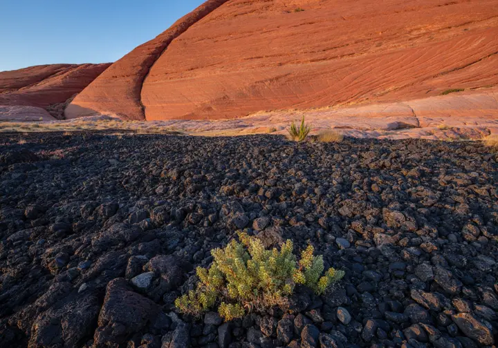
The profound variety of trails around St. George is a direct result of its unique geographic position. The area is a rare meeting point, defined by the convergence of three distinct ecosystems: the Mojave Desert, the Great Basin, and the Colorado Plateau. This confluence creates a startling diversity of landscapes within a remarkably small radius. You can traverse iconic red and white Navajo Sandstone cliffs, navigate fields of black lava flows, and explore the forested heights of the Pine Valley Mountain range.
The geology tells a story of immense forces and deep time. Ancient, wind-blown sand dunes, compressed and mineralized, became the sandstone that defines the region. More recent volcanic activity laid down the cinder cones and basalt fields you see today. Finally, the relentless power of erosion carved the canyons and sculpted the arches that make this region one of the premier bucket list hikes in the USA.
When is the Best Time to Hike (and When Should You Be Cautious)?
Timing your visit to St. George is critical for both enjoyment and safety. The ideal hiking seasons are undoubtedly Spring (March-May) and Fall (September-November). During these months, moderate and pleasant temperatures create perfect conditions for exploring the trails. Winter also offers a fantastic experience, with mild daytime temperatures often in the 50s Fahrenheit and a welcome solitude on otherwise popular routes. A winter trip, however, requires specific skills and gear to handle colder nights and potential precipitation.
Summer (June-August), however, presents a significant and non-negotiable safety risk. Temperatures frequently soar past 100°F, turning trails into ovens and making heat-related illness a serious threat. Hiking during these months must be restricted to the first hours after sunrise and should only be attempted on trails with verifiable shade. Before any hike, regardless of season, always verify current conditions directly with park authorities, as closures and alerts can change rapidly.
[PRO-TIP]: If you must hike in the summer, choose your trail wisely. Start before dawn, be off the trail by 10 a.m., and carry at least one gallon (4 liters) of water per person, even for a short hike.
What are the Essential Safety Principles for Desert Hiking?
The desert is a beautiful but unforgiving environment that demands respect and preparation. Your safety hinges on understanding and mitigating the “Big Three” risks: extreme heat, lack of water, and sudden flash floods. Heat-related illnesses like heat exhaustion and heatstroke are the primary concern, especially in summer. This risk necessitates carrying and consuming more water than you think you need; by the time you feel thirsty, you are already dehydrated.
Flash floods pose a severe and sudden threat in canyon country, a phenomenon well-known to desert backpacking veterans. The danger is most acute during the summer monsoon season (typically July-September), when a distant thunderstorm can send a powerful wall of water rushing through a narrow canyon with little to no warning. Before ever setting foot in a canyon or wash, you must check the latest flash flood potential rating from the National Weather Service. You can learn from the official Virgin River Narrows safety protocols, which provide a model for canyon safety. These specific desert hazards are why carrying the Ten Essentials system is not just a recommendation, but a critical component of every hike.
How Can You Hike Responsibly in this Fragile Ecosystem?
Responsible recreation in this desert landscape is centered on a simple but powerful idea: leave a place better than you found it. This ethic is codified in the official Leave No Trace principles, which include packing out every piece of trash—even organic matter like apple cores or orange peels, which take years to decompose in the arid climate—and respecting wildlife from a distance. By mastering outdoor ethics, you become a partner in conservation.
A critical local concern is the protection of cryptobiotic soil. This dark, bumpy, living crust is foundational to the entire desert ecosystem, preventing erosion and fixing essential nutrients. A single footstep can destroy centuries of growth. This is the crucial “why” behind the number one rule of desert hiking: stay on durable surfaces and marked trails at all times. Park rules are not arbitrary; they are conservation tools designed to protect these places for future generations of people to enjoy.
Which Hikes Should You Explore in Snow Canyon State Park?
Snow Canyon State Park is a 7,400-acre masterpiece of geology, where burnt orange and creamy white Navajo Sandstone rise next to fields of black basalt. Administered by Utah State Parks, official information on fees and regulations is readily available. Before your visit, confirm the cost for a day pass and download a trail map, as cell service can be unreliable inside the park. The trails here offer a concentrated dose of everything that makes the region spectacular.
Southwest Utah Hikin
A detailed look at popular hiking trails near St. George, Utah, including difficulty, features, and key considerations.
Location & Stats
- Location: Snow Canyon SP
- Elevation Gain: 120 – 689 ft
- Cost/Fees: $10-15 (Park Entrance)
- Dog-Friendly: No
Features & Risks
- Key Features: Expansive petrified Navajo Sandstone dunes, slickrock scrambling.
- Seasonal Closures / Risks: No shade; extreme summer heat.
Location & Stats
- Location: Snow Canyon SP
- Elevation Gain: 200 – 400 ft
- Cost/Fees: $10-15 (Park Entrance)
- Dog-Friendly: No
Features & Risks
- Key Features: Accessible lava tubes (caves), jumbled basalt rock fields.
- Seasonal Closures / Risks: Uneven, sharp rock; headlamp needed for caves.
Location & Stats
- Location: Snow Canyon SP
- Elevation Gain: ~20 ft
- Cost/Fees: $10-15 (Park Entrance)
- Dog-Friendly: No
Features & Risks
- Key Features: Short, sculpted slot canyon, family-friendly.
- Seasonal Closures / Risks: Closed March 15 – June 1.
Location & Stats
- Location: Snow Canyon SP
- Elevation Gain: ~200 ft
- Cost/Fees: $10-15 (Park Entrance)
- Dog-Friendly: No
Features & Risks
- Key Features: 200-foot arch, lava flows, lush canyon bottom.
- Seasonal Closures / Risks: Closed March 15 – Sept 14.
Location & Stats
- Location: Snow Canyon SP (area)
- Elevation Gain: 200 – 613 ft
- Cost/Fees: Free
- Dog-Friendly: Yes
Features & Risks
- Key Features: Large cave with views, lava fields, sandy wash.
- Seasonal Closures / Risks: No shade; some route finding.
Location & Stats
- Location: Snow Canyon SP (area)
- Elevation Gain: ~500 ft
- Cost/Fees: Free
- Dog-Friendly: Yes
Features & Risks
- Key Features: Steep hike to the rim of an extinct volcano, panoramic views.
- Seasonal Closures / Risks: Loose, slippery scree.
Location & Stats
- Location: Red Cliffs NCA
- Elevation Gain: 200 – 501 ft
- Cost/Fees: $5 Day Use
- Dog-Friendly: Yes
Features & Risks
- Key Features: Waterfalls/pools, narrow canyon, rope-assisted scramble.
- Seasonal Closures / Risks: High flash flood risk.
Location & Stats
- Location: Red Cliffs NCA
- Elevation Gain: ~200 ft
- Cost/Fees: Free
- Dog-Friendly: Yes
Features & Risks
- Key Features: Sandstone arch, access to Virgin River.
- Seasonal Closures / Risks: High-clearance vehicle required; deep sand.
Location & Stats
- Location: Red Cliffs NCA
- Elevation Gain: 159 – 590 ft
- Cost/Fees: Free
- Dog-Friendly: Yes
Features & Risks
- Key Features: Arch shaped like an elephant, very sandy wash hike.
- Seasonal Closures / Risks: Deep sand can be strenuous.
Location & Stats
- Location: Dixie National Forest
- Elevation Gain: ~300 ft
- Cost/Fees: Free
- Dog-Friendly: Yes
Features & Risks
- Key Features: Swirling, multi-colored sandstone formations.
- Seasonal Closures / Risks: Road may be impassable in winter/wet conditions.
Location & Stats
- Location: Red Mountain Wilderness
- Elevation Gain: 159 – 522 ft
- Cost/Fees: Free
- Dog-Friendly: Yes
Features & Risks
- Key Features: Unique 50-60 ft deep sandstone bowl, slickrock navigation.
- Seasonal Closures / Risks: Route finding requires cairns/GPS.
Location & Stats
- Location: Zion National Park
- Elevation Gain: ~334 ft
- Cost/Fees: Park Fee
- Dog-Friendly: No
Features & Risks
- Key Features: Iconic river hike in a massive slot canyon.
- Seasonal Closures / Risks: High flash flood risk; closed at 150+ CFS.
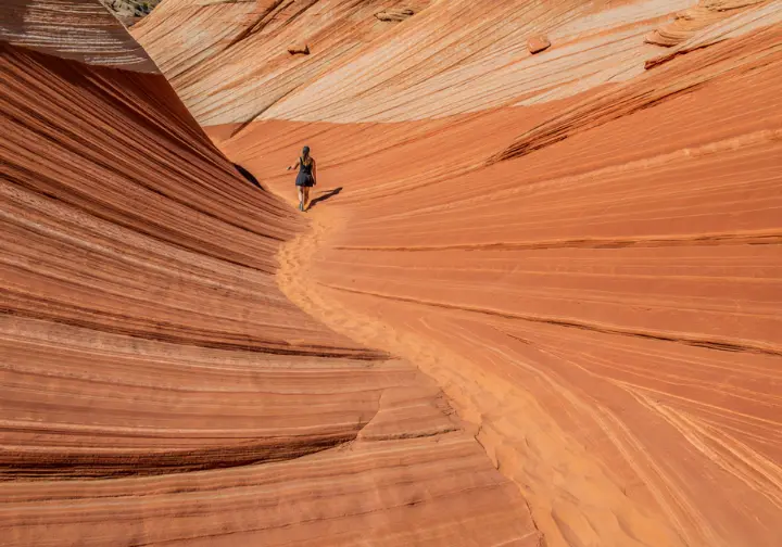
Petrified Dunes Trail: What Do You Need to Know?
This trail features a vast expanse of the famous Petrified Dunes, ancient Navajo Sandstone formations offering a unique opportunity for slickrock scrambling and exploration. The official trail is an easy 1.2-mile loop, but the true experience involves exploring the dunes, which can significantly increase the difficulty and cumulative elevation gain (from ~120 ft to over 600 ft).
Be warned: there is absolutely no shade on this trail. This exposure makes the hike extremely dangerous during summer months due to the high risk of heat exhaustion. Ample water is not a suggestion; it is a non-negotiable piece of safety equipment. Having the right hydration system and choosing the right drinking bottle for the desert heat is a critical part of your planning.
Lava Flow Trail: How Do You Explore the Lava Tubes?
The primary allure of the Lava Flow Trail is the chance to explore several accessible lava tubes—cave-like structures formed by volcanic eruptions thousands of years ago. The trail itself crosses a chaotic field of jumbled, sharp basalt rock. This is not technical rock climbing, but it does require sturdy, closed-toe footwear and careful, deliberate steps to prevent a slip that could result in a nasty scrape or a twisted ankle.
A headlamp or flashlight is essential gear for this hike. It is not optional. You absolutely need a light source to safely navigate the pitch-black, uneven, and rocky interior of the lava tubes.
The official Snow Canyon Trail Map & Brochure provides a great overview of this trail and its unique features.
Johnson Canyon Trail: Why Is This Hike Time-Sensitive?
The Johnson Canyon hike is a delightful, easy 1.7-mile trail that winds through a surprisingly lush canyon bottom, ending at a magnificent 200-foot arch, a feature reminiscent of those found in the more distant Arches National Park. However, the most critical piece of information about this hike is its mandatory seasonal closure. The trail is closed to all hikers annually from March 15th to September 14th.
This closure is not for maintenance; it is a vital conservation measure to protect sensitive wildlife habitat and the nesting sites of breeding raptors. Park authorities enforce the closure strictly, and hiking the trail during this period will result in significant fines. Always verify the exact dates with the park before planning a trip, as they can occasionally change.
What are the Must-Do Trails in the Red Cliffs NCA?
The Red Cliffs National Conservation Area, also known as the Red Cliffs Desert Reserve, is a sprawling, 45,600-acre federal landscape managed by the Bureau of Land Management. It is known for its critical role in protecting the threatened Mojave Desert tortoise and offering more rugged, dispersed hiking experiences than the state parks.
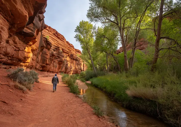
Red Reef Trail: What Are the Risks and Rewards?
The Red Reef Trail, with its trailhead conveniently located near the Red Cliffs Campground, is justifiably famous for a feature that is a true desert luxury: water. The most popular section of the trail is a family-friendly walk leading to small waterfalls and idyllic swimming holes, offering a perfect respite from the heat. This reward—beautiful riparian scenery and a cool dip—makes it one of the most popular trails in the entire region.
This popularity, however, belies a serious risk. The trail follows a narrow canyon, which makes it highly susceptible to flash floods. This is the single greatest danger on this hike. Before entering the canyon, it is imperative that you check the weather forecast and the official flash flood potential rating. For information on fees and access, consult the BLM’s page for The Red Cliffs Recreation Area. Given the trail’s nature, wearing specialized hiking water shoes can dramatically improve your comfort and safety.
Babylon Arch Trail: Is Your Vehicle Ready for This Trailhead?
The Babylon Arch Trail is a short, 1.5-mile route that leads to a picturesque sandstone arch and provides access to the sandy banks of the Virgin River. While the hike is rated as easy to moderate, a significant portion involves plodding through deep, soft sand. This can be surprisingly strenuous and slow-going. Trekking poles can provide extra stability and make navigating the sandy wash much more manageable.
The most critical factor for this hike has nothing to do with the trail itself, but the access road to the trailhead. The road is rough, rutted, and very sandy. A high-clearance, 4-wheel-drive vehicle is strongly recommended. Attempting to reach this trailhead in a standard passenger car carries a very high risk of getting stuck miles from a paved road.
[PRO-TIP]: For remote trailheads like Babylon Arch, never rely solely on your vehicle’s GPS. Always have offline maps and written trailhead directions as a reliable backup.
What Other Iconic Hikes are Near St. George?

While Snow Canyon and Red Cliffs are the main attractions, several of the region’s most iconic hikes lie just outside their boundaries. These featured hikes require slightly different planning but offer some of the most profound and memorable hiking experiences in the American Southwest.
The Narrows (Bottom-Up): How Do You Hike in a River?
This is arguably one of the most famous hikes on the planet. The Narrows involves walking, wading, and sometimes swimming directly in the Virgin River as it flows through a colossal slot canyon in Zion National Park. The scale is breathtaking, with sculpted sandstone walls rising thousands of feet straight from the water. For an in-depth look at navigating Zion National Park, including its mandatory shuttle system, be sure to plan ahead.
The most accessible way to experience this wonder is the “Bottom-Up” hike, which allows you to travel upriver from the Temple of Sinawava as far as you feel comfortable without a permit. The full 16-mile “Top-Down” thru-hike always requires a highly sought-after permit. Safety is the top priority here. The trail is automatically closed by the park service when the river’s flow rate exceeds 150 cubic feet per second (CFS). Before you go, you must consult the official park page for planning your visit to The Narrows to check on closures and flash flood potential.
How Can You Deepen Your Hiking Knowledge?
Moving beyond logistics and trail stats is what transforms a hiker into a true outdoorsperson. Understanding the “why” behind the rules and the techniques required for the terrain elevates your experience and aligns with our core mission of fostering deeper hiking skills, from mastering hiking essentials to understanding complex ecosystems. This knowledge elevates the experience for every hiker, from beginner to advanced hiker.
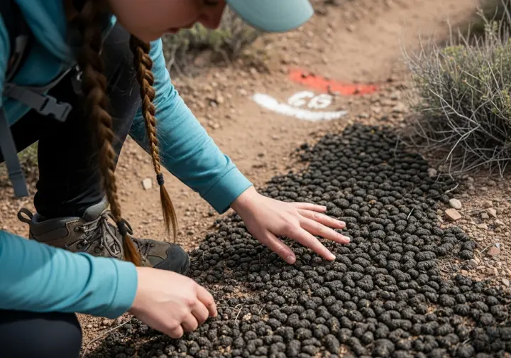
What is Cryptobiotic Soil and Why Is It So Important?
You will see signs about it everywhere, but what is it? Cryptobiotic soil is this living community of microscopic organisms—cyanobacteria, lichens, and fungi—that form a dark, often bumpy crust on the surface of desert soils. This is not just dirt; it is a living entity and the foundation of the entire desert ecosystem.
This “living glue” binds sand particles together, preventing catastrophic erosion from wind and water. It also absorbs precious rainfall and converts nitrogen from the atmosphere into a form that other desert plants can use to grow.
This living crust is extraordinarily fragile. A single, careless footstep can destroy decades, and in some cases centuries, of growth. Its destruction is, for all practical purposes, permanent. This is why staying on marked trails is the most important act of stewardship a desert hiker can perform.
What Are the Best Techniques for Navigating Slickrock?
The term “slickrock” is one of the great misnomers of the American West. It was coined by early pioneers whose metal-shod horses and iron-rimmed wagon wheels found the vast expanses of sandstone dangerously slippery. For the modern hiker, the opposite is true. When dry, the wind-polished Navajo Sandstone provides exceptionally good grip for rubber-soled footwear, allowing you to confidently walk up and down surprisingly steep inclines on the face of sheer rock cliffs.
The key is choosing hiking footwear with superior traction, specifically a sticky rubber outsole. While the grip is excellent, a fall on slickrock is unforgiving and can act like a cheese-grater on exposed skin. On the steepest sections, maintain three points of contact. Be especially cautious of thin layers of loose sand on the rock surface, which can act like tiny ball bearings underfoot and cause a sudden slip.
Conclusion
- St. George offers an unparalleled diversity of hikes due to its location at the junction of the Mojave, Great Basin, and Colorado Plateau ecosystems.
- Successful hiking in the region depends on planning around the seasons to avoid the life-threatening heat of summer and being constantly aware of the risk of flash floods in canyons.
- The most unique and authoritative information in this guide is the “Master Trail Data Table,” which clarifies conflicting data points found elsewhere, and the “Hiker as Steward” angle, which explains the ecological “why” behind park rules.
- Acting as a steward of the land—by staying on trails to protect fragile cryptobiotic soil and respecting all closures and regulations—is the most important responsibility of any hiker in this area.
Call to Action: Explore our complete library of expert-led Hiking Guides to find your next adventure.
Frequently Asked Questions about Hiking Near St. George
Is St. George good for hiking?
Yes, St. George is considered a world-class, year-round hiking destination. Its unique location provides access to an incredible variety of landscapes, from red rock canyons and lava fields in places like Snow Canyon to the iconic slot canyons of nearby Zion National Park.
What is the best month to hike in St. George, Utah?
The best months for hiking in St. George are in the spring (March-May) and fall (September-November). These seasons offer the most moderate and pleasant temperatures for being outdoors. Winter is also excellent, while summer is dangerously hot.
How long are typical hikes near St. George?
The hikes near St. George vary widely, from a short hike or easy hike for families to strenuous all-day treks over 10 miles long. The most common and popular trails, such as those in Snow Canyon and Red Cliffs, are typically in the 1.5 to 4-mile range.
What is the hardest hike in St. George, Utah?
While “hardest” is subjective, many hikers agree one of the most physically demanding hikes is the Cinder Cone Trail, which involves a steep 500-foot climb on loose volcanic scree to the rim of an extinct volcano. Other challenging hikes include strenuous, long-distance routes in Zion National Park or backcountry explorations that require advanced navigation skills.
Risk Disclaimer: Hiking, trekking, backpacking, and all related outdoor activities involve inherent risks which may result in serious injury, illness, or death. The information provided on The Hiking Tribe is for educational and informational purposes only. While we strive for accuracy, information on trails, gear, techniques, and safety is not a substitute for your own best judgment and thorough preparation. Trail conditions, weather, and other environmental factors change rapidly and may differ from what is described on this site. Always check with official sources like park services for the most current alerts and conditions. Never undertake a hike beyond your abilities and always be prepared for the unexpected. By using this website, you agree that you are solely responsible for your own safety. Any reliance you place on our content is strictly at your own risk, and you assume all liability for your actions and decisions in the outdoors. The Hiking Tribe and its authors will not be held liable for any injury, damage, or loss sustained in connection with the use of the information herein.
Affiliate Disclosure: We are a participant in the Amazon Services LLC Associates Program, an affiliate advertising program designed to provide a means for us to earn advertising fees by advertising and linking to Amazon.com. As an Amazon Associate, we earn from qualifying purchases. We also participate in other affiliate programs and may receive a commission on products purchased through our links, at no extra cost to you. Additional terms are found in the terms of service.


