

In this article
While a postcard from Yosemite or Zion can inspire a dream, it rarely shows the grueling ascent or the competitive permit lottery required to get there; this guide bridges that gap by deconstructing America’s most iconic hikes, ranking them not by beauty alone, but by the specific skill and preparation needed to earn the view. These are the journeys that test your limits and redefine your capabilities, creating a comprehensive bucket list of the best hikes in the USA.
Here is an actionable framework for your hiking aspirations:
- Discover a four-level system that ranks each hike by the cumulative skills required, from foundational adventures to epic thru-hikes.
- Learn the specific technical challenges of famous backpacking trails, such as navigating the river-as-trail in The Narrows or ascending the Half Dome cables.
- Understand that the biggest challenge is often logistical—mastering the competitive permit lotteries and reservation systems now required for most top-tier national park hikes.
- Get actionable, data-driven trail guides for each featured hike, covering gear, logistics, and skill development to conquer the most challenging terrain.
How Are These Bucket List Hikes Ranked?

This framework moves beyond vague labels like “easy” or “hard,” empowering you to accurately assess your abilities and choose the right challenge. It explains the unique four-level ranking system used to create a progressive roadmap toward the most demanding and rewarding hikes in the US.
What Defines Each Skill & Preparation Level?
The ranking system is designed as a progressive roadmap for any hiker. Each level builds upon the skills of the last, ensuring you develop the competence needed for ever-greater challenges. According to the National Park Service, a key component of preparedness is understanding the trail you plan to hike and being honest about your physical abilities; our system provides a clear structure for that self-assessment, based on the principles outlined in the NPS guidance on hiking safety.
- Level 1: Foundational Adventures. These are iconic, high-reward bucket list hikes with low technical barriers. These easy hikes are accessible to most fit individuals and are perfect for building confidence while mastering the fundamentals of hiking. Preparation focuses on understanding the Ten Essentials and basic trail etiquette.
- Level 2: Technical Day Hikes. These trails introduce a specific, non-standard challenge, such as extensive hiking in water or minor scrambling, requiring specialized gear or skills beyond simple walking on a dirt path. A day hike at this level is a significant step up.
- Level 3: Strenuous Summits & Treks. This category includes long, high-elevation day hikes or short backpacking trips that demand a significant step up in physical conditioning and mental fortitude. These challenging hikes often involve exposure to heights, technical sections requiring precision, and frequently necessitate navigating a competitive permit lottery to reach the summit.
- Level 4: Epic Expeditions. This is the pinnacle of hiking, representing multi-week thru-hikes that represent a total wilderness immersion. A true bucket list trek at this level, a thru-hiking marathon, requires comprehensive logistical planning, from intricate resupply strategies to a deep understanding of ultralight gear and long-term endurance.
Epic US Hikes: A Comparison Guide
Discover challenging trails across national parks and forests, from single-day adventures to multi-week treks.
Location & Type
Zion National Park, UT. Out-and-back trail through the Virgin River.
Details
Elevation Gain: ~1,017 ft. Typical Duration: 1 Day. Skill & Prep: Moderate, requires wading/swimming and permits.
Location & Type
Glacier National Park, MT. Out-and-back to a stunning glacier lake.
Details
Elevation Gain: ~1,620 ft. Typical Duration: 1 Day. Skill & Prep: Moderate, involves uphill hiking and potentially snow.
Location & Type
Yosemite National Park, CA. Out-and-back trail with a famous cable ascent.
Details
Elevation Gain: ~4,800 ft. Typical Duration: 1 Day. Skill & Prep: Difficult, requires cables section and lottery permit.
Location & Type
Zion National Park, UT. Out-and-back trail with exposed chains section.
Details
Elevation Gain: ~1,827 ft. Typical Duration: 1 Day. Skill & Prep: Difficult, requires high exposure tolerance and permit.
Location & Type
Inyo National Forest, CA. Out-and-back to the highest peak in the contiguous US.
Details
Elevation Gain: ~6,200 ft. Typical Duration: 1-3 Days. Skill & Prep: Difficult, requires high altitude acclimatization and permits.
Location & Type
Sierra Nevada, CA. Point-to-point through stunning high Sierra wilderness.
Details
Elevation Gain: ~47,000 ft. Typical Duration: 2-4 Weeks. Skill & Prep: Expert, requires extensive backpacking experience and permits.
Location & Type
Grand Teton NP, WY. Point-to-point through high alpine terrain.
Details
Elevation Gain: ~9,000 ft. Typical Duration: 3-5 Days. Skill & Prep: Expert, requires significant backpacking experience and permits.
What Skills Do Level 2 Technical Day Hikes Require?
Hikes at this level move beyond simple walking, introducing specific environmental or technical obstacles that demand deliberate preparation, specialized gear, and the acquisition of new skills. They push hikers to adapt their tactics to the terrain in new and challenging ways.
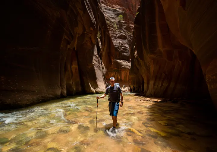
How Do You Prepare for The Narrows River Hike in Zion?
The primary challenge of this unforgettable hike in Zion National Park is not the elevation gains, but the environment itself. Your success and safety depend entirely on preparing for prolonged immersion in cold water, navigating an unstable riverbed, and respecting the constant, life-threatening danger of flash floods. The official NPS guidance for hiking The Narrows is the first and most critical resource for any aspiring hiker.
Flash flood safety is non-negotiable. A storm miles away can send a wall of water rushing through the canyon with shocking speed. Before entering, you must check the official NPS Flash Flood Potential forecast. The hike provides a practical education in “reading the river”—learning to use poles to probe for depth, identify the path of least resistance, and brace against the current.
Gear strategy for this unique environment is paramount. Standard waterproof boots will fill with water and become dangerously heavy. Instead, opt for specialized canyoneering shoes or lightweight trail runners that drain quickly. Pair them with neoprene socks to keep feet insulated and prevent blisters. Finally, a sturdy set of trekking poles is essential equipment, providing the stability needed to navigate the slippery, unseen riverbed of this amazing trail.
| Attribute | Data |
|---|---|
| Location | Zion National Park, UT |
| Distance | Up to 15 miles (variable, bottom-up) |
| Elevation Gain | ~1,017 ft |
| Difficulty | Moderate to Strenuous |
| Permit | Not required for bottom-up day hike to Big Spring. Wilderness Permit required for top-down or travel beyond Big Spring. |
What Are the Main Challenges of the Grinnell Glacier Trail?
The journey to Grinnell Glacier is a masterclass in modern National Parks logistics. The biggest challenge for this popular hike is often not on the trail, but online. Accessing the trailhead during peak season requires more than a standard park pass; you must secure a separate, highly competitive vehicle reservation through the Glacier’s vehicle reservation system at Recreation.gov.
Timing is also critical. As a high-elevation alpine trail, Grinnell Glacier is often not clear of hazardous snow until mid-to-late July. You must check the official NPS Trail Status Report for current conditions before your hike. For any early or late-season attempt, traction devices like microspikes are strongly recommended for steep, icy snowfields. The Many Glacier valley, part of a vast mountain range, also has one of the highest concentrations of grizzly bears in the lower 48, making bear spray mandatory for every group.
| Attribute | Data |
|---|---|
| Location | Many Glacier, Glacier National Park, MT |
| Distance | 7.2 miles (with boat) / 10.4 miles (without boat) |
| Elevation Gain | ~1,620 ft |
| Difficulty | Strenuous |
| Permit | Park Entrance Pass & Many Glacier Vehicle Reservation required in peak season. No specific hiking permit. |
How Do You Prepare for Level 3 Strenuous Treks?
Preparation for these iconic hikes tests physical fitness, mental toughness, and strategic planning for competitive permits. Success on these strenuous ascents is a genuine badge of honor in the hiking community, a testament to dedication, training, and fortitude.
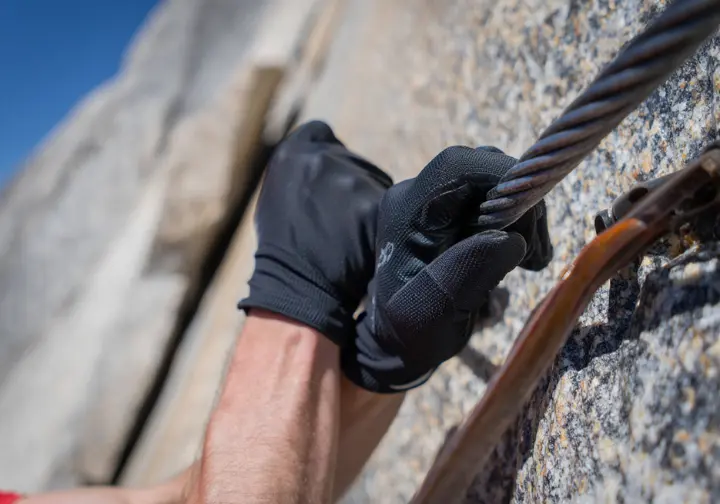
How Can You Win a Permit for the Half Dome Hike?
The Half Dome challenge is twofold: first, the logistical battle of winning the permit, and second, the grueling physical and mental test of the hike itself. The first obstacle is securing access through the official Half Dome permit system, a lottery on Recreation.gov where success rates hover around just 22%. To maximize your odds, apply for weekdays, target the shoulder season of late August through October, and keep your group size small.
This hard day hike is a monumental day of exertion, covering a 15-mile hike with nearly 5,000 feet of elevation gain. Your training must simulate this demand. The final 400-foot ascent is a thrilling and exposed scramble up the infamous cables, where gear and technique are everything. Sturdy, nitrile-coated work gloves provide superior grip compared to leather, and footwear with sticky rubber soles is mandatory for the slick granite. Mental fortitude is paramount; the key is to focus only on moving from one wooden plank to the next and never attempt the cables if the rock is wet.
| Strategy | Rationale | Supporting Data/Sources |
|---|---|---|
| Apply for Weekdays | Demand is significantly lower during the week. | The daily lottery success rate in 2024 was 22% on weekdays versus only 14% on weekends. |
| Target the Shoulder Season | Application numbers decrease after the peak summer season as school resumes and weather becomes less predictable. | Application numbers gradually decrease starting in late August, with October numbers being roughly half of the summer peaks. |
| Keep Group Size Small | Smaller groups have a higher probability of fitting into the few remaining slots on a popular day. | The lottery system fills a quota of 225 hikers. A request for 2 people can be fulfilled if 2 slots are left, whereas a request for 6 cannot. |
| Be Flexible and Use All Choices | The lottery application allows for multiple date choices or date ranges. Using this feature increases the number of opportunities to win. | Applicants can select up to seven preferred dates or date ranges. |
| Utilize the Daily Lottery | If you have geographic flexibility, the daily lottery provides another opportunity to win, especially if you can try for multiple consecutive weekdays. | The daily lottery offers a ~19% chance of success and can be entered each day. |
| Consider a Backpacking Permit | A wilderness permit for an overnight trip with a Half Dome add-on is another route, though also competitive. | 75 permits per day are allocated to backpackers. This requires different planning but is a viable alternative. |
What Does It Take to Tackle a Level 4 Epic Expedition?
The zenith of the USA bucket list involves multi-week thru-hikes that demand mastery of logistics, endurance, and self-sufficiency. These are not weekend trips but profound wilderness immersions that test every facet of a hiker’s knowledge and character, demanding more than heavy backpacking packs can carry in one go.
How Do You Plan a John Muir Trail (JMT) Thru-Hike?
Undertaking the 211-mile John Muir Trail is a massive backpacking trip. Securing a southbound permit from Yosemite is the first hurdle; you must enter a rolling weekly lottery 24 weeks in advance, a process governed by the official NPS regulations for the John Muir Trail. This is one of the most competitive lotteries in the country.
The logistical heart of thru-hiking the JMT is the resupply master plan. It is impossible to carry three weeks of food, so you must mail packages to designated points like Muir Trail Ranch. A mistake here can jeopardize the entire trip. Gear strategy revolves around two items: the mandatory bear-resistant food canister required by law and adopting an ultralight philosophy to minimize the weight of your backpack, shelter, and sleep system. Finally, physical preparation must build chronic endurance through back-to-back, multi-day backpacking trips with a weighted pack to simulate the cumulative stress of weeks at high altitude.
John Muir Trail Resupply Points
A comprehensive guide to planning your food and gear resupply along the JMT.
Shipping Details
Mail via USPS to Tuolumne Meadows Post Office.
Key Services & Notes
Optional first stop. Store has limited supplies. Post office hours/operation can be inconsistent.
Shipping Details
Mail via USPS. 5-gallon bucket recommended. Must mail authorization form & fee in advance.
Key Services & Notes
Crucial first resupply. Has a small store, cafe, and lodging. Sells fuel canisters.
Shipping Details
Mail via USPS or UPS. Box or bucket OK. Located 4.5 miles off-trail (ferry option available).
Key Services & Notes
Optional stop. Famous for hiker hospitality (first beer is free). Has a restaurant, store, lodging.
Shipping Details
MUST use a 5-gallon plastic bucket. Mail via USPS Priority Mail 3+ weeks in advance.
Key Services & Notes
Critical last resupply. Extremely remote. No services for non-guests except package pickup and hiker boxes.
Shipping Details
No public service. Requires a 15-mile round-trip hike over Kearsarge Pass. Must use a private service or arrange for a friend to meet you.
Key Services & Notes
Difficult but strategic final resupply to lighten the load for the final high passes and Mt. Whitney.
Conclusion
The journey through America’s bucket list trails is a progressive path, providing a clear roadmap from foundational adventures to epic hikes. The nature of these challenges has evolved; the difficulty of modern bucket list hiking is now equally logistical and physical. Successfully navigating permit lotteries and reservation systems is as crucial as your physical training. Each level of hike demands new, specific skills—from reading a river in The Narrows to long-range resupply planning for the JMT. The goal is to foster competent, responsible recreation by providing a data-driven framework that empowers you to be safe, prepared, and a respectful steward of these iconic landscapes.
Explore our complete library of hiking skill guides to prepare for your next hiking trip.
Frequently Asked Questions about USA Bucket List Hikes
What is the hardest bucket list hike in the USA?
Difficulty is subjective and depends on whether you mean a single-day effort or a long-distance expedition. For a day hike, Half Dome is a top contender due to its 5,000+ feet of elevation gain and mentally taxing cable ascent, while the 211-mile John Muir Trail represents an extreme test of long-term endurance and logistics.
Do you always need a permit for a bucket list hike?
No, but the most famous and sought-after hiking paths almost always require a permit to manage crowds and protect the environment. Hikes like Half Dome, the JMT, and Angels Landing all use highly competitive lottery systems, making the permit the first major challenge.
What are some good bucket list hikes for beginners?
Beginners should look for “Level 1” or “Level 2” hikes that offer iconic views without extreme technical barriers. Excellent starting points for day hiking could include the Emerald Lake Trail in Rocky Mountain National Park or the easier sections of The Narrows in Zion, both of which provide high rewards for manageable effort.
What is the most important piece of gear for these hikes?
The most important gear is always hike-specific and goes beyond the standard Ten Essentials. For example, nitrile-coated gloves are critical for the Half Dome cables, a sturdy trekking pole is non-negotiable for The Narrows, and an approved bear canister is required by law for the JMT.
Risk Disclaimer: Hiking, trekking, backpacking, and all related outdoor activities involve inherent risks which may result in serious injury, illness, or death. The information provided on The Hiking Tribe is for educational and informational purposes only. While we strive for accuracy, information on trails, gear, techniques, and safety is not a substitute for your own best judgment and thorough preparation. Trail conditions, weather, and other environmental factors change rapidly and may differ from what is described on this site. Always check with official sources like park services for the most current alerts and conditions. Never undertake a hike beyond your abilities and always be prepared for the unexpected. By using this website, you agree that you are solely responsible for your own safety. Any reliance you place on our content is strictly at your own risk, and you assume all liability for your actions and decisions in the outdoors. The Hiking Tribe and its authors will not be held liable for any injury, damage, or loss sustained in connection with the use of the information herein.
Affiliate Disclosure: We are a participant in the Amazon Services LLC Associates Program, an affiliate advertising program designed to provide a means for us to earn advertising fees by advertising and linking to Amazon.com. As an Amazon Associate, we earn from qualifying purchases. We also participate in other affiliate programs and may receive a commission on products purchased through our links, at no extra cost to you. Additional terms are found in the terms of service.


