

In this article
- Strategic Planning & Preparation: Your Batur Blueprint
- The Trekking Experience: A Hiker’s-Eye View
- Safety, Risk & Responsibility on an Active Volcano
- Beyond the Hike: The Geological & Cultural Context of Batur
- Your Mt. Batur Trek: Key Takeaways for the Trail
- Frequently Asked Questions about the Mt. Batur Trek
This guide moves beyond generic tourist advice to provide dedicated hikers with the in-depth knowledge needed to plan, execute, and responsibly enjoy the Mt. Batur trek. We’ll cover everything from technical gear choices and terrain analysis to the complex ethical considerations of this iconic Balinese adventure. This is not just about seeing the sunrise over Gunung Batur; it’s about understanding the living volcano beneath your feet.
Strategic Planning & Preparation: Your Batur Blueprint

The success of your Mount Batur experience is determined long before you arrive at the trailhead. We will detail the critical decisions and logistical planning needed to build a solid foundation for your trek, analyzing tour options, optimal timing, and the pro-level gear required for a safe and rewarding hike.
Choosing Your Adventure: Key Decisions Before Booking
Your first choice for this adventure is between the physical test of the hike and the comfort of a 4WD Jeep tour. The hiking offers a profound sense of accomplishment but demands a solid level of cardiovascular fitness for the steep ascent. Conversely, the sunrise jeep tour grants access to incredible mountain views without strenuous effort, making it suitable for those with mobility concerns or families with young children, though it bypasses the immersive trail experience.
Furthermore, your selection of a private Mount Batur tour versus a group excursion will directly affect your budget, pace, and overall experience. Group treks are more wallet-friendly, but they lock you into a fixed pace. A private tour offers complete flexibility to set your own speed, a fact many a Tripadvisor member review will confirm, making it ideal for photographers or hikers with specific fitness needs.
Finally, consider the optimal timing. Bali’s dry season, from April to October, is the best time to visit. This peak season offers the highest probability of clear skies, spectacular sunrises, and safer trail conditions for the sunrise trek. While you can trek year-round, months like September often offer pleasant conditions. The wet season, from November to March, brings frequent rain. Proper planning and preparation for your first hike is magnified in the dry season, and the type of tour will also influence the typical cost for a guided tour.
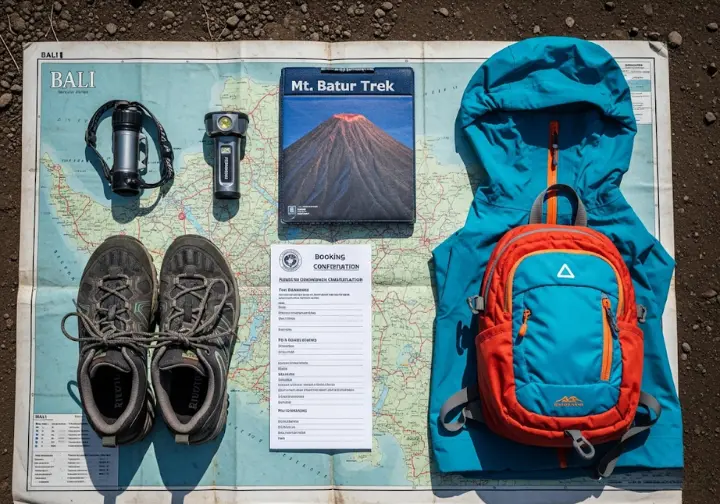
A Technical Gear Guide for the Serious Hiker
Proper footwear is non-negotiable for safety on Batur’s varied terrain; standard trainers are simply not enough. The ideal choice is a hiking shoe or trail runner with deep, aggressive lugs for superior grip on the treacherous, loose volcanic scree you’ll find on the upper slopes. Ankle support, while not mandatory, is highly recommended to prevent twists on rocky sections. Thoroughly selecting footwear based on specific hike’s terrain is a core preparation step before you even leave the car park.
This trekking also demands a smart 3-phase layering strategy for the dramatic microclimate shifts. Start with a moisture-wicking base layer to manage sweat during the humid ascent. Add an insulating mid-layer, like a fleece jacket, for the cold and windy summit where temperatures can drop to 10°C (50°F). A lightweight, packable windproof or waterproof shell is the final essential piece. Learning what to wear for the Mt. Batur trek is key.
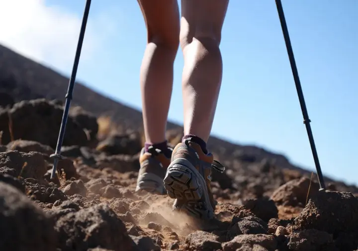
Beyond clothing, certain items are critical. A high-quality headlamp is mandatory for the pre-dawn climbing in total darkness. Trekking poles are highly recommended to reduce knee strain during the descent and offer stability on loose gravel; these poles are invaluable. You should also pack at least 1.5-2 liters of water, a camera, and some cash for potential purchases at the summit.
The Trekking Experience: A Hiker’s-Eye View
We move beyond generic descriptions to provide an on-the-ground, practical analysis of the routes, terrain, and the real challenges you will face—all from a dedicated hiker’s perspective. This is what the actual mountain trail is actually like at this popular hiking spot.
An Honest Assessment of Trek Difficulty
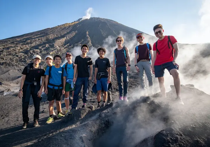
While tour operators often label this as a pleasant trek or “beginner-friendly,” this can be misleading for people with a sedentary lifestyle. The main challenge of this challenging night hike is cardiovascular. The hour-long climb is consistently steep, requiring significant “huffing and puffing” and sustained effort. Many first-hand accounts of the hike’s difficulty describe legs feeling “like jelly,” showing the strenuousness of the climb up the mountain.
The most common route from Toya Bungkah can be deconstructed into segments. It begins with a flat access road before transitioning to a dusty path through farmland. It then enters a forest section with a much steeper grade. The final third is the most demanding, involving a scramble over larger volcanic rocks and navigating the summit cone of loose, slippery scree where every two steps forward can feel like one step back. Adapting your pace to the terrain is the key to managing your energy through these sections.
Guides often focus on the ascent, but the descent is just as demanding, if not more so. The trail down is covered in loose gravel and volcanic sand. This creates a very slippery, unstable surface that puts considerable strain on the knees and requires careful footwork to avoid falls. This is where trekking poles become invaluable for stability.
Mastering Volcanic Terrain: A Technical Guide
“Volcanic scree” refers to the loose, gravel-like fragments of rock covering the upper cone. It shifts underfoot, making this no fun hike if you’re unprepared. Ascending requires a steady, deliberate pace, planting your feet firmly to minimize energy-wasting slips. Proper footwear with superior traction from outsoles with deep, aggressive lugs is your best defense against the scree.
The descent on scree demands specific techniques to maintain control and protect your joints. On softer sections, employ the “plunge step,” a controlled, heel-first motion that lets your heel dig in. On harder, more gravelly parts, a side-stepping or “crab-walk” motion works well, keeping your center of gravity low. Using hiking poles here will provide excellent lateral stability.
On Batur, trekking poles are not just walking aids; they are critical safety equipment. Use them to probe for stable ground and to create two extra points of contact, which significantly improves your balance. Concentrate on your footwork: take smaller steps, keep your knees bent to absorb impact, and test your footing before fully committing your weight. These are fundamental skills for tackling tough terrain on hikes.
Trekking Route Analysis: Choosing Your Path
The most popular of the ascent routes is the main tourist trail from Toya Bungkah. Starting near a local pasar (market), it is a well-worn track that takes about 1.5 to 2.5 hours to ascend. While it’s the most straightforward choice for the sunrise hike, you should be prepared to share this out-and-back trail with hundreds of other hikers.
For a more challenging alternative, the trail from Serongga Village is known for being quicker but significantly steeper. It is a great option for fit hikers who are short on time and wish to avoid the largest crowd—sunrise hikes attract many people. It offers a more peaceful and personal experience.
For hikers who prioritize solitude over the classic summit, the Batur Caldera trek is an excellent choice. This easier of the local hikes follows the rim of the outer caldera, providing stunning panoramic views of the mountain and Lake Batur without the intense crowds. This is a perfect example of exploring lesser-known hidden gem trails. You can find more details on the quieter Batur Caldera hike through local operators.
Safety, Risk & Responsibility on an Active Volcano
A clear-eyed assessment of the inherent risks—geological, human, and environmental—is essential. We aim to equip you with the knowledge to navigate them responsibly, ensuring your trek is both safe for you and respectful to the local community and environment.
The Ethical Hiker’s Guide to Local Engagement
The term “guide mafia” describes the community-enforced system at the mountain’s base where independent hikers are often told it’s mandatory to hire a local tour guide. While not nationally illegal to hike alone, this system is a deep-rooted part of the local economy, providing income for families in the Kintamani region. Viewing it only as a “scam” overlooks this complex socio-economic reality.
As a competent hiker, you face an ethical choice. Hiring a guide you may not need for navigation directly supports the local economy and is viewed as a sign of respect. Going without a guide saves money but may lead to uncomfortable confrontations, a point you’ll find echoed on any good tour app. A balanced approach could involve hiring a guide but ensuring they add value through local knowledge.
If you choose to hike independently, be prepared, polite, and firm. You can read some firsthand accounts of avoiding the mountain mafia online. Acknowledge the person at the checkpoint, state your intention clearly, and continue on your way without aggressive arguments. This is a core part of embracing responsible hiking practices.
Volcanic Hazards & Emergency Preparedness
Mount Batur is an active stratovolcano, with its last minor eruption occurring in 2000. Its activity is monitored 24/7 by Indonesia’s official volcanic monitoring body, the PVMBG. They set the safety status and will halt all trekking if any heightened risk is detected, making your trip part of a foundational safety system for hikers.
Beyond eruptions, hikers should be aware of specific on-trail hazards. These include hot steam vents near the main crater and other crater rims, which can cause serious burns if touched. Additionally, some areas may have a thin crust over hollow lava tubes, so it is absolutely necessary to stay on the well-established paths to avoid collapsing the ground.
Before your trek, save local emergency numbers in your phone. The primary number for Search and Rescue (BASARNAS) in Bali is 115, and for general emergencies, you can call 112. Ensure your guide has a reliable communication method, and always inform someone of your itinerary and expected return time.
Leave No Trace: The Batur Edition
The high volume of traffic, sometimes up to 600 hikers daily, puts immense pressure on Batur’s fragile volcanic ecosystem and its natural scenery. The standard Leave No Trace principles must be strictly followed. This includes packing out all of your trash, including food scraps like banana peels and eggshells, as they do not decompose quickly in this environment.
The mountain also has no permanent toilet facilities. If you must go, walk at least 70 big steps away from the trail and any water sources and dig a “cathole” 6-8 inches deep to bury human waste. Critically, stay on the established trail at all times; cutting switchbacks or creating new paths accelerates erosion. This environmental awareness is a form of proactive hazard management. The problem is real, with academic research on tourism’s environmental damage at Mount Batur showing its effects.
The principle of “Leave What You Find” extends to cultural artifacts. You may see small woven palm-leaf offerings, called canang sari, along the trail. These are part of religious ceremonies and should be left completely undisturbed. Honoring the mountain’s sacred status is a core part of responsible trekking, similar to the Leave No Trace principles for volcanic parks in other parts of the world.
Beyond the Hike: The Geological & Cultural Context of Batur
Understanding the forces that shaped Mount Batur and its sacred place in Balinese culture transforms a simple hike into a richer experience. It provides context for the ground you walk on and the incredible scenery you admire.
The Earth-Shaping Power of a Double Caldera
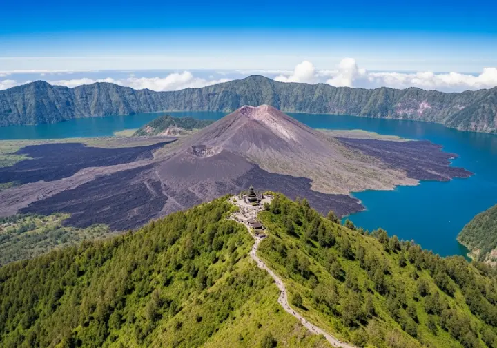
The most stunning feature of the landscape is Batur’s double caldera system. The vast outer caldera was formed by a cataclysmic eruption around 29,300 years ago. A subsequent major eruption about 20,150 years ago created the smaller, circular inner caldera, inside which the modern cone of the volcano has grown. You can review the volcano’s historical eruption data and geological context to appreciate its power.
In recognition of this unique geological heritage, the entire area was designated a UNESCO Global Geopark in 2012. This status highlights its global significance and reinforces the need for sustainable tourism to preserve its natural and cultural value. The landscape you trek through is a direct result of these violent past events, blanketing much of Bali in volcanic rock. The fertile soil that supports the region’s agriculture is a product of this activity, making your trek a walk through a living geological museum. You can find in-depth geological analysis of the Batur Geopark from scientific bodies.
A Sacred Mountain: Dewi Danu and Balinese Hinduism
For the Balinese people, Mount Batur is not just a geological formation; it is a sacred site, second in holiness only to the mighty Mount Agung. The mountain is considered a source of life and fertility, deeply connected to the island’s spiritual well-being. This context elevates it beyond a simple tourist attraction.
The volcano is spiritually home to Dewi Danu, the Balinese Hindu goddess of Lake Batur and, by extension, all water sources on the island. She is revered as the protector of the intricate subak irrigation systems that are vital for Bali’s rice cultivation. This connection explains the deep reverence locals have for the two connected mountains.
The cultural importance of the site is manifested in Pura Ulun Danu Batur, one of Bali’s nine key directional temples. Originally located on the volcano’s slopes, it was destroyed in a 1926 eruption and painstakingly relocated to its current location on the caldera rim. It remains a crucial center for religious ceremonies dedicated to Dewi Danu, showing the sacred status of Bali’s volcanoes.
Your Mt. Batur Trek: Key Takeaways for the Trail
Success on the Mount Batur hike depends less on raw strength and more on smart preparation. This includes choosing the right gear for volcanic terrain—especially footwear with excellent grip—and employing a technical layering system to handle the drastic temperature changes. The “guide” situation is a complex socio-economic issue, so approach it with respect and understanding, making a conscious choice that aligns with your values.
Remember that you are a guest on a fragile, active, and sacred volcano. Your responsibility is to minimize your impact by strictly adhering to Leave No Trace principles, staying on the trail to prevent erosion, and showing reverence for this must-visit destination. The Batur sunrise trek is enriched by understanding its context. Learning about the powerful geology of the caldera and the spiritual importance of Dewi Danu transforms the physical act of hiking into a deeper, more meaningful engagement with the breathtaking Mount Batur.
Frequently Asked Questions about the Mt. Batur Trek
How difficult is the Mt. Batur trek for a beginner? +
Can you really cook eggs in the volcano? +
Is the Mt. Batur jeep tour worth it compared to the hike? +
What happens if the volcano becomes active? +
We are a participant in the Amazon Services LLC Associates Program, an affiliate advertising program designed to provide a means for sites to earn advertising fees by advertising and linking to Amazon.com. As an Amazon Associate I earn from qualifying purchases. We also participate in other affiliate programs. The information provided on this website is provided for entertainment purposes only. We make no representations or warranties of any kind, expressed or implied, about the completeness, accuracy, adequacy, legality, usefulness, reliability, suitability, or availability of the information, or about anything else. Any reliance you place on the information is therefore strictly at your own risk. Additional terms are found in the terms of service.


