

In this article
- The 2025 Hiking App Matrix: A Quick Comparison
- The Contenders: In-Depth Reviews of the Best Hiking Apps
- Core Concepts: Understanding the Tech Behind the Trail
- Solving Hiker Problems: From Battery Drain to Data Privacy
- Final Verdict: Building Your Hiker’s Digital Toolbox
- Frequently Asked Questions about Hiking Apps and GPS
Modern hiking apps have become essential digital tools, largely replacing traditional navigation methods for many hikers. This shift from paper maps and a compass to GPS-based mobile applications is a primary change in how we explore the great outdoors. Yet, this creates a common problem: the market is crowded with apps all claiming to be superior, making the choice of a reliable hiking app confusing. This guide offers a clear, comprehensive comparison of the best hiking apps available, tackling the Gaia GPS vs AllTrails debate and more to help you choose the best tool for your specific hiking style. We recognize that the “best” overall hiking app is not a one-size-fits-all solution; it depends entirely on whether you’re a casual day-hiker or a serious backcountry explorer planning multi-day treks. Our promise is to deliver a detailed, data-driven look at the top contenders for 2025, empowering you to build your own “hiker’s digital toolbox.”
The 2025 Hiking App Matrix: A Quick Comparison

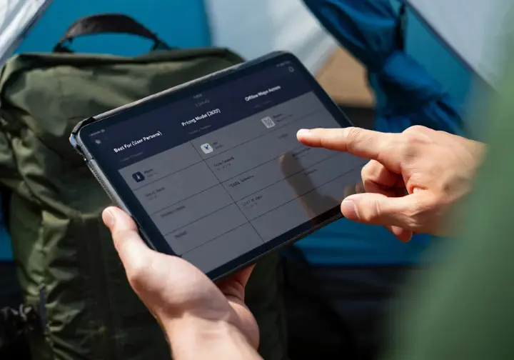
This section provides a summary table that helps you quickly compare the top applications across key criteria. It allows you to see the main differences between these popular hiking apps at a glance before you dive into the detailed reviews that follow.
At-a-Glance Feature & Value Matrix
To provide immediate value, a clear table comparing the top 7 worthy hiking apps—AllTrails, Gaia GPS, onX Backcountry, Komoot, FarOut, CalTopo, and PeakFinder—is invaluable for those seeking quick answers. The matrix includes columns for “Best For (User Persona),” “Pricing Model (2025),” “Key Pro Feature,” “Offline Maps Access,” and “Primary Data Source,” permitting a fast, direct comparison of the most critical app attributes. This table serves as a high-level summary. The following sections offer an in-depth app review to help you understand the nuances behind each recommendation. We’ve also included the most current 2025 pricing available, from freemium tiers to subscriptions, to address the important factor of cost.
The Contenders: In-Depth Reviews of the Best Hiking Apps
This core section delivers detailed profiles for each major application. Each review covers functionality, pricing, and the ideal user, going beyond a simple feature list to explain how each app performs in the real world for various adventures.
AllTrails: The Social Trail Discoverer
AllTrails’ greatest strength is its massive, crowd-sourced database of over 450,000 hiking trails, making it the market leader for trail discovery. It answers the question, “Where should I hike near me?” with millions of useful reviews, photos, and real-time condition reports. The Alltrails app follows a three-tier freemium model. The free version provides ad-supported online map access, but the AllTrails+ tier ($35.99/yr) is vital for most hikers, unlocking offline maps for hiking, wrong-turn alerts, and the “Lifeline” safety feature.
A new top-tier “Peak” subscription ($79.99/yr) was introduced in 2025, adding advanced AI-driven tools. These include an AI-assisted custom route builder and hyper-detailed trail condition predictions for things like snow depth and even mosquito activity. AllTrails is perfectly suited for beginners, casual day-hikers, and families looking for their next great hike. Its user-friendly interface makes it the go-to app for finding popular and well-documented hikes and is one of the top free options including AllTrails. The University of Connecticut provides a useful reference for its core functions of finding trails and recording tracks.
Gaia GPS: The Backcountry Navigation Powerhouse
For serious mountain navigation, Gaia GPS is the best tool for the job. It’s widely seen as a digital substitute for a dedicated handheld GPS unit. Its defining feature is a vast and diverse catalog of professional map layers for an enhanced hiking experience. You get access to hundreds of authoritative map sources, including USGS Topo, USFS maps, high-resolution satellite imagery, and the prized National Geographic Trails Illustrated topographical maps. The free version is quite limited, offering only the basic standard Gaia Topo layer for online viewing.
The app’s true power is unlocked with the Premium subscription ($39.99/yr), which provides the entire Gaia GPS map catalog and the critical ability to download any layer for offline use in remote areas. This Gaiagps app is built for serious backpackers, off-trail adventurers, and outdoor professionals who need reliable navigation tools. This depth comes with a notable learning curve that can challenge beginners. For those who rely on it, any changes to the app are a big deal, leading some to discuss the enshittification of Gaia GPS after its corporate acquisition. This focus on advanced skills means that mastering navigation with a map, compass, and GPS backup is a related and critical skill.
onX Backcountry: The Land Boundary Specialist
Having evolved from the successful onX Hunt app, its standout feature is the clear, accurate visualization of public and private land boundaries. This valuable tool is invaluable for navigating the complex patchwork of land ownership common in many regions, especially the American West, clearly showing various terrain features and landmarks. The app has a Premium tier ($29.99/yr) with standard features like topo maps and offline downloads. The Elite tier ($99.99/yr) is what provides the key differentiator: detailed private land data, including landowner names, and more frequently updated satellite imagery.
Beyond hiking, onX includes dedicated modes for sports like backcountry skiing and mountain biking. It is particularly essential for hunters, anglers, and anyone recreating in areas with mixed land ownership who must confidently avoid trespassing. Many users debate the finer points of OnX or Gaia? based on their specific needs for mountain hiking and land access.
Komoot: The European Route Planner
Komoot is a dominant force in the European market, known for its sophisticated, sport-specific route planning engine. It excels at creating optimized routes for hiking, cycling, and mountain biking with reliable turn-by-turn voice navigation. Its pricing is unique, centered on a one-time purchase system for offline access to maps by region, including detailed European topo maps. You get one “Single Region” for free and can then buy additional regions or a “World Pack” (€29.99) for permanent offline use. A separate Premium subscription ($59.99/yr) adds a multi-day tour planner and live tracking.
A controversial change in 2025 now requires new users to have a Premium subscription to sync planned routes to external Garmin or Wahoo devices, a feature previously available with a one-time map purchase. The change has prompted detailed analysis of Komoot’s expanded paywalls. Komoot is the ideal choice for international travelers, and its robust features demonstrate why excellent planning tools are essential for hiking in Europe, whether in the Alps or the Brecon Beacons National Park.
FarOut: The Thru-Hiker’s Bible
FarOut, formerly Guthook, is a hyper-specialized digital guidebook, not a general-purpose mapping app. It is the indispensable, non-negotiable tool for thru-hikers on popular long-distance trails like the Appalachian Trail (AT), Pacific Crest Trail (PCT), and Continental Divide Trail (CDT). Its value comes from an exhaustive, waypoint-based dataset for each trail, providing crucial logistical information on water sources, campsites, and town services that serves as a lifeline for thru hiking.
The data stays remarkably current through real-time trail updates from a dedicated community of on-trail hikers. This provides timely intelligence on critical details, like whether a water source is flowing or dry, which other apps lack. The pricing model is a one-time purchase per trail guide, though a “FarOut Unlimited” subscription is also available. When thru-hikers ask, “What hiking apps do you prefer?,” FarOut is consistently named for long-distance journeys on iconic trails like the Appalachian Trail.
Core Concepts: Understanding the Tech Behind the Trail

This section demystifies the key technologies powering modern GPS apps for hiking. It helps build your foundational knowledge so you can make more informed decisions and use your chosen app more effectively and safely.
GPX Files Explained
A GPX (GPS Exchange Format) file is the universal language for sharing GPS data between apps and devices. It is a text file containing geographic coordinates that define waypoints, routes, and tracks. It’s useful to understand the difference between a “route” and a “track.” A route is a pre-planned path you intend to follow, while a track is a detailed “breadcrumb” record of where you have actually been. The ability to import and export GPX files is a fundamental feature of any serious hiking app. To learn more, Cicerone Press offers a great explanation of what are GPX files?.
Crowd-Sourced vs. Curated Data
The source of an app’s trail data is a critical and often-debated factor. Crowd-sourced maps, used heavily by apps like AllTrails, come from a massive community of users, offering a huge library of trails and recent condition reports. The primary drawback of crowd-sourced data is its potential for dangerous inaccuracies. Unvetted user tracks can have wrong names, optimistic time estimates, or follow non-existent paths, sometimes leading to hikers getting lost. These issues with AllTrails are well-documented.
Curated data, found in apps like Gaia GPS, comes from authoritative sources like government agencies (USGS, USFS). This data, including professional topographical mapping, is highly accurate and considered the gold standard for critical navigation where safety is paramount. The most effective strategy is using both data types together. Use crowd-sourced platforms for route discovery, but always cross-reference the route on a curated topo map for safety, which reinforces beginner advice about staying on marked trails.
Responsible Hiking with Apps
Modern outdoor apps can be powerful tools for practicing the seven Leave No Trace principles. The principle of “Plan Ahead and Prepare” is embodied by using an app to research trail stats, elevation, weather, and recent user reports to ensure you are well-prepared. Apps help hikers “Travel on Durable Surfaces” by using topo and satellite map layers to visualize the terrain and identify established trails. You can satisfy curiosity without violating “Leave What You Find” by using an app’s identification features or dropping a waypoint to research wildlife or a trail feature later.
Features that show trail popularity, like “Community Heatmaps” in AllTrails, help you “Be Considerate of Other Visitors” by choosing less-crowded trails. Practicing these principles, as outlined by The Leave No Trace Seven Principles, is part of responsible hiking. This ethos is underpinned by carrying the right gear, including essential navigation tools (map, compass).
Solving Hiker Problems: From Battery Drain to Data Privacy

This section directly addresses the most common pain points users experience with hiking apps. It moves beyond features to provide actionable solutions for frustrations like battery drain, subscription fatigue, and privacy concerns, building reader trust.
The Battery Preservation Masterclass
A primary safety concern for app users is rapid battery depletion from continuous GPS navigation. A dead phone means losing your primary navigation tool. The most effective strategy is using your phone in airplane mode while allowing the GPS chip to function. This cuts off battery-draining cellular and Wi-Fi signals searching for a connection. Proactively manage your phone’s settings by lowering screen brightness and turning off background app refreshes.
Only turn on the screen when you need to check your location. Despite these measures, you should never rely solely on your phone. Carrying a fully charged external power bank is a non-negotiable piece of safety equipment in your pack. This preparedness mindset extends to all your hiking gear must-haves, including illumination. Users often discuss which is the most battery efficient GPS app to minimize this issue from the start.
Behind the Map: The Business of Your Hiking App
Many hikers are wary of the business practices behind their favorite hiking apps, experiencing “subscription fatigue.” A key concern is “enshittification,” where app quality seems to decline after a corporate acquisition in favor of profit. This concern is not unfounded; acquisitions of Gaia GPS by Outside Inc. and Komoot by Bending Spoons were followed by price increases and feature changes, frustrating longtime users. Data privacy is another major anxiety.
Hikers are worried about how their location data is being collected and used, with some apps being called a “privacy nightmare.” When choosing an app, it’s critical to look beyond the feature list and consider the company’s business model and privacy policy. Noted long-distance hiker Andrew Skurka details why he has made CalTopo his go-to mapping & GPS navigation choice, considering many of these factors. This article empowers you to make a choice that aligns with your needs and values.
Final Verdict: Building Your Hiker’s Digital Toolbox
The conclusion reinforces the central theme: there is no single “best” all-around hiking app, but rather a “digital toolbox” of specialized applications. This summary provides final, actionable recommendations based on user personas. The most important takeaway is to abandon the idea of one perfect app. Experienced hikers adopt a “digital toolbox” approach, using multiple apps for different tasks like discovery, trip planning, and on-trail navigation.
- For Beginners and Casual Discovery: Start with AllTrails. Its massive trail database is unmatched for finding your next day hike.
- For Serious Backcountry Navigation: Gaia GPS is the top choice. Its superior catalog of curated, professional map layers makes it the most reliable tool for remote exploration and off-path mountain use.
- For Meticulous Planners & Advanced Users: CalTopo is the professional-grade standard. Use its powerful web tools for pre-trip planning, especially where analyzing slope angle on steep terrain is critical.
- For Thru-Hikers: FarOut is absolutely essential. Its waypoint-based logistical data is a lifeline no other app provides for long thru hikes.
Frequently Asked Questions about Hiking Apps and GPS
What is the best completely free hiking app? +
As a beginner, should I choose AllTrails or Gaia GPS? +
Do I still need a paper map and compass if I have a GPS app? +
Is it worth paying for a premium subscription like AllTrails+ or Gaia Premium? +
We are a participant in the Amazon Services LLC Associates Program, an affiliate advertising program designed to provide a means for sites to earn advertising fees by advertising and linking to Amazon.com. As an Amazon Associate I earn from qualifying purchases. We also participate in other affiliate programs. The information provided on this website is provided for entertainment purposes only. We make no representations or warranties of any kind, expressed or implied, about the completeness, accuracy, adequacy, legality, usefulness, reliability, suitability, or availability of the information, or about anything else. Any reliance you place on the information is therefore strictly at your own risk. Additional terms are found in the terms of service.


