

In this article
- Defining Glacier’s Best Hikes
- Highline Trail: Iconic Ridge Walk
- Grinnell Glacier: Up Close Glacier Views
- Pitamakan-Dawson Loop: Epic Ridge Traverse
- Iceberg Lake: Dramatic Cirque Lake
- Avalanche Lake: Forest and Waterfalls
- Navigating Park Logistics Effectively
- Discovering Less-Crowded Gems
- Planning Your Glacier Adventure
- Frequently Asked Questions
The potential list of must do hikes in glacier national park is dazzling, making choices difficult! While Glacier National Park offers stunning beauty, accessing its famed hikes requires navigating real-world logistics. This guide provides a realistic look. We balance the allure of superstars like Highline, Grinnell, Pitamakan-Dawson, Iceberg, and Avalanche Lakes against the challenges of crowds, reservations, and effort. What must you consider to do these epic hikes? We’ll explore logistics, quieter gems, and planning strategies for your adventure in the park.
This isn’t just another list; it’s a realistic look at what it takes to experience the top hikes in Glacier National Park. We aim to equip you with the insights needed to choose the right path for your adventure, ensuring your hiking journey in this magnificent park is as rewarding as the destinations themselves. Ready to chart your course?
Defining Glacier’s Best Hikes


Selecting the definitive “best” hikes in Glacier National Park presents a unique challenge. The park’s most breathtaking trails often come bundled with significant hurdles like overwhelming crowds and complex reservation systems, demanding a realistic approach beyond simple beauty rankings.
Understanding Hiker Goals
Many prospective visitors start their planning by searching for curated lists – “Top 5,” “Best Day Hikes,” often categorized by difficulty or features like glaciers or waterfalls. This shows a clear need for straightforward recommendations to kickstart the journey. We see people wanting more than just names; they actively seek detailed trail stats like distance, elevation gain, time estimates, difficulty ratings, and descriptions of scenic highlights for popular routes.
A major focus for hikers inevitably becomes navigating the practical side. This includes understanding parking strategies (or lack thereof), managing or avoiding crowds, deciphering the vehicle reservation system, and knowing crucial bear safety protocols. Have you found yourself overwhelmed by these logistics before? It’s a common feeling.
Furthermore, hikers expect realistic difficulty assessments. Simple labels aren’t enough; understanding why a trail is rated a certain way—steepness, exposure, length—helps gauge if it truly matches personal capabilities. There’s also a growing trend towards seeking less-crowded alternatives, reflecting a desire to escape the congestion on famous trails. Visual previews through photos are highly sought after, offering a glimpse before committing. Trustworthy information, like that from the National Park Service and reputable hiking resources, is paramount.
Balancing Beauty And Reality
Glacier National Park is undeniably a hiker’s paradise, carved by ancient glaciers, offering stunning scenery with dramatic peaks, turquoise lakes, and over 700 miles of hiking trails. It’s a landscape that pulls you in. However, this immense popularity creates significant logistical challenges. Think extreme crowds, parking lots full before sunrise, and complex vehicle reservation systems for key areas.
The most famous trails, like Highline and Grinnell Glacier, consistently lauded for beauty, often present the greatest difficulties. Successfully hiking them requires meticulous planning, which can sometimes impact the overall visitor experience. Remember the friend who spent more time circling for parking than actually hiking? It happens. Defining the “best” hike is ultimately subjective, depending on fitness, experience, crowd tolerance, and desired scenery. Difficulty ratings also vary, demanding honest self-assessment.
Access rules, especially vehicle reservations and area restrictions (like the planned 2025 Many Glacier changes), are dynamic. Diligently checking the official NPS website before and during your trip is crucial. Proper preparation is non-negotiable: carry bear spray, sufficient water, extra layers for volatile mountain weather, and understand basic safety. Think of it as packing your map and your compass for the journey ahead. Consider selecting hiking footwear based on the specific hike’s terrain as a foundational step.
Highline Trail: Iconic Ridge Walk
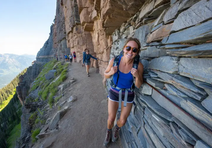
Arguably Glacier’s most famous hike, the Highline Trail offers an unforgettable journey along the Garden Wall, but demands respect for its logistical hurdles and exposure. It’s a trek that truly tests your planning skills as much as your legs.
Trail Logistics And Access
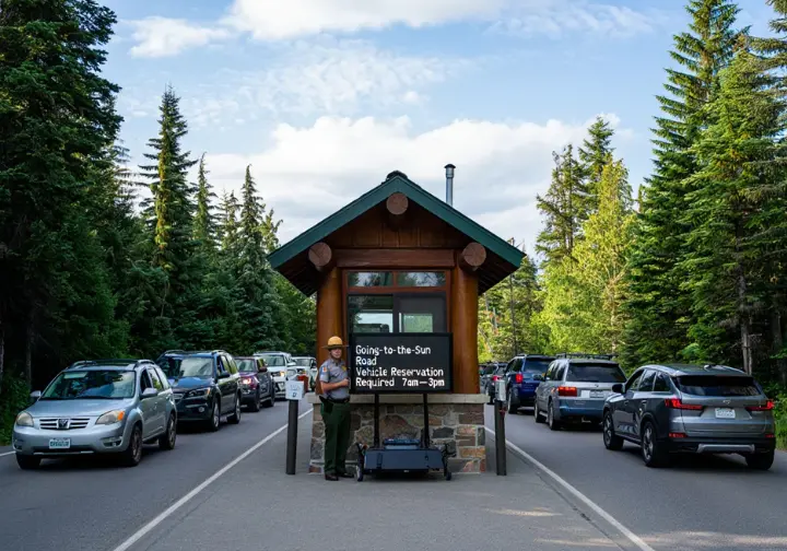
Typically hiked point-to-point, the Highline Trail stretches about 11.4 to 11.8 miles from Logan Pass down to The Loop trailhead. This route involves significant elevation loss (around 3000 ft) and a moderate gain (about 800 ft), making it a long day on your feet. Accessing the start at Logan Pass is the first challenge. Parking is extremely limited, often full before 7 AM, and requires navigating the Going-to-the-Sun Road (GTSR) vehicle reservation system during peak season (typically 7 AM – 3 PM for west side access).
Using the free park shuttle is highly recommended. The common strategy involves parking at The Loop (finish) and taking the shuttle up to Logan Pass (start). However, be prepared for potentially long waits for the return shuttle later in the day. Remember, the GTSR vehicle reservation, secured via Recreation.gov, is separate from your park entrance fee.
For those wary of shuttle logistics or the steep final descent, an out-and-back hike from Logan Pass towards Haystack Pass (roughly 7.2 miles roundtrip) is a great alternative. Timing remains crucial regardless; an early start (pre-7 AM) is key for parking, while July and August offer peak wildflowers but also peak crowds. It’s a trade-off many hikers weigh carefully.
Scenery And Key Highlights
The Highline Trail delivers continuous, breathtaking panoramic views. You’ll traverse high along the Garden Wall section of the Continental Divide, with the Going-to-the-Sun Road winding far below. Expect spectacular vistas of iconic peaks like Heavens Peak, Mt. Oberlin, and Mt. Cannon – it’s a photographer’s dream landscape. During July and August, abundant alpine meadows often burst with wildflowers, adding vibrant color.
Wildlife sightings are frequent. Mountain goats and bighorn sheep are common companions, sometimes surprisingly close to the trail. Keep an eye out for marmots sunning themselves on rocks, and perhaps even bears grazing in distant meadows (always maintain a safe distance!). A challenging but rewarding spur trail climbs steeply (1.6-1.8 miles RT, 900+ ft gain) to the Grinnell Glacier Overlook, offering a commanding view down onto Upper Grinnell Lake.
Around the 7.6-mile mark (from Logan Pass), you’ll reach the historic Granite Park Chalet. While services are limited, it provides a welcome resting spot and a fascinating glimpse into the park’s past lodging history. It’s a tangible link to the hikers who walked this path generations ago.
Challenges And Considerations
Be prepared: the Highline Trail is extremely popular and often crowded, especially the initial miles from Logan Pass. Solitude is a rare find during peak season. The infamous “Ledge” section, about a quarter-mile in, is a narrow path (4-8 feet wide) with steep drop-offs and a hand cable. It’s short (~0.3 miles), but can be genuinely unnerving for those with a significant fear of heights. I recall guiding a friend once who froze solid there; deep breaths and focusing on the cable got us through.
Much of the trail is exposed to sun and wind. Ample water, sunscreen, hats, and layered clothing are essential to manage changing conditions. While often rated Moderate overall (starting from Logan Pass), the hike’s length (11+ miles) and the steep descent (~3000 ft) to The Loop demand good endurance and can be tough on the knees. Successfully completing this hike requires robust logistical planning – parking or shuttles, reservations, and effective time management.
Beyond the ledge, remember the overall physical demands of a long day hike at altitude. Fatigue is real, and adequate nutrition is key. Finally, trail conditions vary. Snow often lingers at higher elevations into July. Checking the NPS trail status report before heading out is absolutely essential for safety and preparedness.
Grinnell Glacier: Up Close Glacier Views
The Grinnell Glacier Trail is a pilgrimage for many visiting Many Glacier, offering intimate views of shrinking glaciers and stunningly colored lakes. Access changes planned for 2025 make understanding the logistics more critical than ever.
Trail Logistics And Access
The full hike from the Many Glacier Hotel area covers 10.6 miles roundtrip. However, most hikers opt for the Glacier Park Boat Co. shuttle across Swiftcurrent Lake and Lake Josephine. This significantly shortens the trek to about 7.2-7.8 miles roundtrip and bypasses less scenic sections, saving energy for the main climb. Booking these boat tickets far in advance is crucial – they sell out incredibly fast.
Parking near the Many Glacier Hotel or the Grinnell Glacier Trailhead fills extremely early, often by 8 AM. If driving, plan for a crack-of-dawn start. Crucially, for the 2025 season (July 1 – Sept 21), personal vehicle access to Many Glacier is restricted due to construction. Entry will require a pre-booked service reservation (like the boat tour) or a separate temporary hiker shuttle ticket obtained via Recreation.gov. This is a major change requiring careful planning.
Even with the boat assist, the hike involves a significant elevation gain of roughly 1600 feet. This climb is concentrated primarily in the steep latter half leading up to the glacier viewpoint. Remember to factor the boat schedule into your day, allowing ample time for the hike and potential waits to avoid missing the last return trip.
Scenery And Key Highlights
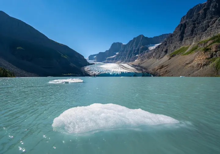
The trail’s reward is the breathtaking, up-close view of Grinnell Glacier, the smaller Salamander Glacier clinging high on the Garden Wall, and the stunningly turquoise Upper Grinnell Lake, fed by glacial melt. It’s a powerful reminder of the forces that shaped this landscape. Looking down, you’ll see the equally beautiful, slightly greener Grinnell Lake nestled in the valley below.
Several picturesque waterfalls cascade down the surrounding cliffs, adding to the sensory experience, especially during high snowmelt. The Many Glacier valley offers excellent wildlife viewing potential. Moose are sometimes spotted near the lakes, while bighorn sheep and mountain goats frequent the higher slopes. Bears are also commonly reported, making vigilance essential.
During peak summer (July/August), the slopes along the trail are often adorned with vibrant displays of alpine meadows and wildflowers. Near the upper lake, keep an eye out for ancient stromatolite fossils embedded in the rocks – remnants of microbial life billions of years old, a fascinating geological treasure amidst the grandeur.
Challenges And Considerations
This trail is extremely popular and often crowded, particularly on the upper sections and near the boat docks. Starting early is vital, even if you have boat reservations. Don’t underestimate the strenuous nature of the hike; that 1600-foot climb, even over fewer miles, is a significant effort. Upper portions often hold snow well into July, potentially requiring careful navigation across snowfields. Always check the NPS trail status report.
The viewpoint near the glacier can be considerably colder and windier than lower elevations, even on warm days. Packing extra layers is non-negotiable. Given the high frequency of bear sightings in Many Glacier, hikers must be vigilant, hike in groups, make noise, and carry readily accessible bear spray, knowing how to use it. Navigating the 2025 access restrictions adds a significant layer of planning complexity. Addressing this well in advance is key to a successful visit.
Pitamakan-Dawson Loop: Epic Ridge Traverse
For experienced hikers seeking a challenging, rewarding journey with potentially fewer crowds, the Pitamakan-Dawson Pass Loop in the Two Medicine area is an epic undertaking, offering miles of breathtaking ridge walking.
Trail Logistics And Access
This strenuous loop covers a significant distance, typically estimated between 14.8 and 18 miles, combining sections of the Pitamakan Pass and Dawson Pass trails. It involves substantial elevation gain, usually cited between 2400 and 3000+ feet, as it climbs over two high mountain passes. Access is via the Two Medicine valley entrance, which notably does not require a vehicle reservation for the 2025 season, making it an appealing alternative.
The loop usually starts at the North Shore Trailhead near the Two Medicine Campground. It can be hiked clockwise (Pitamakan first) or counter-clockwise (Dawson first). Many prefer counter-clockwise for potentially better views approaching the high ridge. A boat shuttle on Two Medicine Lake offers a potential shortcut, shaving off some distance near the end, but check schedules carefully.
Due to its length and difficulty, this is a full-day commitment requiring 7 to 10+ hours. An early start and careful time management are essential to complete it safely before dark. It’s a serious undertaking demanding respect and preparation.
Scenery And Key Highlights
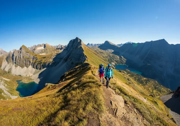
The undisputed highlight is the extended traverse along the narrow, dramatic ridge connecting Pitamakan Pass and Dawson Pass. This section offers miles of continuous, jaw-dropping 360-degree panoramic views – a true feast for the eyes. From this high perch, you’ll gaze upon numerous peaks, valleys, and lakes, including Oldman Lake, No Name Lake, Pumpelly Pillar, and Mount Stimson.
The route provides glimpses into the remote Nyack Creek drainage to the west, showcasing the vast wilderness character of Glacier National Park. Compared to the heavily trafficked trails elsewhere, this loop offers a significantly greater sense of solitude and immersion. What value do you place on solitude during your hikes?
Wildlife like bighorn sheep and mountain goats are frequently seen along the high ridges. Encounters with marmots, pikas, and potentially bears are also possible. Similar to Grinnell Glacier, observant hikers might spot stromatolite fossils near the passes, adding a unique geological layer to the stunning visual landscape.
Challenges And Considerations
This loop is consistently rated as Strenuous to Very Strenuous. Its substantial length (15-18 miles) and significant elevation gain demand excellent physical fitness and endurance. The high ridge section involves narrow trail segments with considerable exposure to steep drop-offs, making it unsuitable for those with a strong fear of heights or vertigo. It demands focus and steady footing.
Being highly exposed, the ridge is vulnerable to strong winds and rapidly changing mountain weather. Appropriate layers and careful forecast checks are critical. Snow can linger on the high passes and north-facing slopes well into July, potentially creating hazardous conditions or requiring microspikes or even an ice axe early in the season.
Completing this demanding hike requires careful planning regarding water (carry plenty or know reliable filter sources), nutrition (pack high-energy food), and pacing. While less crowded than GTSR hikes, it’s still a known epic loop. Be prepared for potential bear encounters and follow all recommended bear safety protocols diligently throughout the journey.
Iceberg Lake: Dramatic Cirque Lake
The Iceberg Lake Trail in Many Glacier is a popular choice, famous for the chunks of ice often floating in the lake well into summer, all framed by a dramatic cirque. It offers a rewarding destination with a more gradual climb than its neighbor, Grinnell.
Trail Logistics And Access
This is an out-and-back hike covering approximately 9.3 to 10.4 miles roundtrip. The trailhead is located behind the Swiftcurrent Motor Inn complex in Many Glacier. The elevation gain is steady but generally moderate, around 1200 to 1450 feet, making the climb feel less intense compared to the steep push up to Grinnell Glacier.
Parking near the Swiftcurrent Motor Inn serves multiple popular trailheads (like Ptarmigan Tunnel) and fills very early, often before 8 AM. Similar to Grinnell, access to the Many Glacier valley in 2025 (July 1 – Sept 21) is restricted. You’ll need either a service reservation or a temporary hiker shuttle ticket secured via Recreation.gov.
No boat shuttle assists this trail; you must cover the full distance on foot. Plan for 5 to 7 hours, depending on your pace and how long you linger at the lake. The trail shares its initial ~2.7 miles with the Ptarmigan Tunnel trail, so expect company, especially early on.
Scenery And Key Highlights
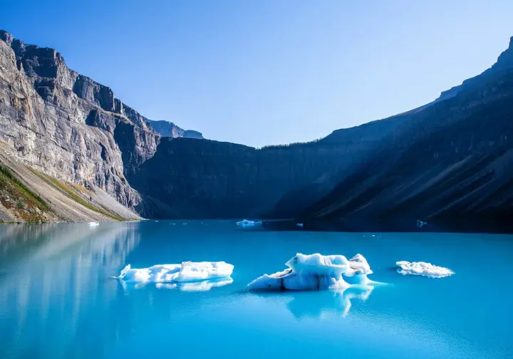
The destination, Iceberg Lake, is the star. It’s a stunningly scenic lake nestled dramatically within a high-walled glacial cirque below Mount Wilbur and Iceberg Peak. The lake is famous for often retaining large chunks of floating ice (icebergs) well into July and August, creating a unique and highly photogenic spectacle.
Throughout the hike, particularly after gaining some elevation, you’re treated to expansive panoramic views looking back down the lush Many Glacier valley. About 2.4 miles in, the trail passes Ptarmigan Falls, a scenic spot for a quick rest before continuing the climb. Mid-summer brings colorful alpine wildflowers to the meadows along the trail, enhancing the visual appeal.
For the brave (or perhaps foolish!), taking a quick, frigid “polar plunge” into Iceberg Lake is a popular, albeit brief, way to mark reaching the destination. It certainly wakes you up!
Challenges And Considerations
Iceberg Lake is a very popular hike. Expect to share the trail with many others, especially midday in July and August. This trail traverses prime grizzly bear habitat. Encounters are relatively common in the Many Glacier area. Carrying bear spray, making noise, hiking in groups, and constant awareness are absolutely essential safety measures.
Temporary trail closures due to frequent bear activity are possible, particularly later in summer when berries ripen. Always check the NPS trail status report before you go. Snow can linger on shaded sections and around the lake basin well into July, potentially obscuring the path or requiring careful navigation.
The presence and size of icebergs vary significantly depending on the time of year and recent temperatures. Arriving later in the summer might mean seeing less ice. And remember, the 2025 access restrictions for Many Glacier require advance planning via Recreation.gov to secure your entry reservation or shuttle ticket.
Avalanche Lake: Forest and Waterfalls
On the park’s west side, the Avalanche Lake Trail offers a different flavor of Glacier beauty, combining a unique walk through an ancient cedar forest with a picturesque lake framed by cascading waterfalls. Its accessibility makes it popular, but also brings significant crowd and parking challenges.
Trail Logistics And Access
The total roundtrip distance is approximately 4.5 to 6.0 miles, which includes the easy, initial 1-mile loop through the Trail of the Cedars. The elevation gain is relatively moderate, around 500 to 750 feet, with most climbing occurring after leaving the cedar loop. The trailhead is at the Trail of the Cedars / Avalanche Picnic Area turnoff from Going-to-the-Sun Road, near Lake McDonald.
Parking here is extremely limited and fills notoriously fast, often full well before 9 AM in peak season, sometimes even before 8 AM. It’s one of the most challenging lots in the park. Using the free park shuttle (Avalanche Creek stop) is highly recommended to avoid parking frustration, though shuttle waits are possible. Accessing this area from the west glacier entrance during peak hours (7 AM – 3 PM) also requires a Going-to-the-Sun Road vehicle reservation.
The hike typically takes 2 to 3 hours, making it a popular choice for families or those seeking a shorter but scenic outing.
Scenery And Key Highlights
The initial Trail of the Cedars section is a highlight in itself. It’s an easy, accessible walk (partly boardwalk) through a lush, ancient forest of giant western red cedars and hemlocks – a stark contrast to the high alpine scenery elsewhere. Within this loop, bridges cross Avalanche Gorge, offering dramatic views of turquoise water carving through narrow rock.
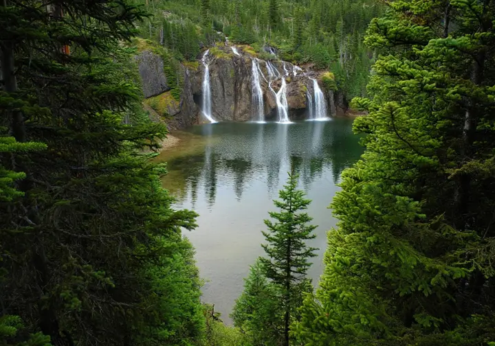
After leaving the cedars, the Avalanche Lake trail climbs steadily alongside scenic Avalanche Creek through the forest. The destination, Avalanche Lake, sits beautifully in a steep-walled basin. It’s famous for the multiple thin, ribbon-like waterfalls cascading down the surrounding cliffs, originating from Sperry Glacier high above (though the glacier itself isn’t visible).
This combination of old-growth forest and a picturesque lake-and-waterfall finale provides significant scenic variety in a relatively short hike. The Trail of the Cedars portion is also wheelchair accessible, opening up the unique forest environment to more visitors.
Challenges And Considerations
This is one of the most popular hikes in Glacier National Park. Expect extremely high levels of crowding on both the Trail of the Cedars loop and the path up to Avalanche Lake, especially midday. Securing parking is a major challenge and a significant source of frustration. Arriving before 8 AM, visiting late afternoon/evening, or using the shuttle are the most viable strategies.
The Trail of the Cedars loop, while beautiful, can feel particularly congested. While generally rated Easy/Moderate, the climb up to Avalanche Lake is consistently uphill and can be tiring for those unaccustomed to hiking or elevation gain. Sections of the trail, particularly near the lake, can become muddy after rain or during spring melt.
Successfully hiking Avalanche Lake often requires strategic timing or reliance on the shuttle system to mitigate the significant parking and crowd pressures. It’s a beautiful destination, but requires patience or clever planning to fully enjoy.
Navigating Park Logistics Effectively
Experiencing Glacier’s stunning beauty requires navigating a complex web of logistics. Understanding crowds, parking, reservations, shuttles, and safety protocols is key to a smoother, more enjoyable journey through the park.
Conquering The Crowd Factor
Glacier National Park sees intense summer visitation, leading to significant congestion on roads, at popular trailheads (Logan Pass, Avalanche, Many Glacier), visitor centers, and on shuttles. Some iconic spots see over 1,500 hikers daily; solitude is rare on famous routes in peak season. Adjusting expectations is crucial. Dealing with crowds is part of the modern Glacier experience.
To minimize crowds, plan hikes for very early morning (arrive before 7 AM) or late afternoon/early evening (after 4 PM). Consider exploring less-visited areas like Two Medicine, Cut Bank, or the North Fork for stunning scenery with fewer people. Visiting during shoulder seasons (early June or September) can also help, though weather is more variable. Practice good trail etiquette – yield to uphill hikers, stay on marked trails, pack out everything – to lessen impact.
Solving The Parking Puzzle
Parking at popular trailheads like Logan Pass, Avalanche Lake, and Many Glacier hubs is extremely limited and routinely fills before sunrise, often by 6:30 or 7 AM. Arriving exceptionally early is the most reliable strategy if driving. A common mistake is arriving at 8 AM expecting a spot – it’s usually too late.
Utilizing the free park shuttle along Going-to-the-Sun Road is a key alternative, bypassing the parking hunt but requiring patience for potential waits. Hiking later in the day (after 3-4 PM) might yield open spots as early birds depart, but requires careful time management. Always have backup plans; if a lot is full, move on rather than waiting or parking illegally, which damages resources and risks citations.
Decoding Vehicle Reservations
Glacier implements vehicle reservations for specific areas (GTSR West, North Fork, Many Glacier in 2025) during peak season/hours (typically 7 AM – 3 PM). These are required in addition to a park pass and are obtained via Recreation.gov. They are highly competitive, released 120 days in advance and the day before, often selling out in minutes.
To bypass the need for a reservation, enter restricted areas before 7 AM or after 3 PM, use an unrestricted entrance (like St. Mary for GTSR in 2025), or visit areas without requirements (like Two Medicine in 2025). Valid service reservations (lodging, boat tours) often substitute for the vehicle pass on service days – check current NPS rules carefully. Rules change annually; verify the current year’s requirements on the official NPS website. The 2025 Many Glacier restriction requires a service or specific shuttle reservation for entry.
Utilizing Shuttle Systems
The free GTSR shuttle runs between Apgar Village and St. Mary Visitor Center, stopping at key trailheads. It’s a crucial alternative to driving but be prepared for potentially long waits (up to an hour+) at major hubs like Logan Pass, especially during peak times. Factor this into your schedule.
Shuttles heading west from Logan Pass in the afternoon often fill quickly. Buses arriving at intermediate stops like The Loop may have very limited space. Know the shuttle operating hours and plan your hike to finish well before the last shuttle departs (usually around 7 PM from Logan Pass). Missing it can leave you stranded. Boarding at main transit centers (Apgar or St. Mary) generally offers a better chance of getting a seat. The temporary 2025 Many Glacier shuttle will operate under separate ticketing rules.
Prioritizing Bear Safety
Glacier National Park has high densities of grizzly and black bears. Encounters are possible on any trail, making safety paramount. Carrying bear spray and knowing how to use it effectively is essential; keep it accessible, not buried in your pack. Check the expiration date before your trip. Hiking in groups of three or more is strongly recommended.
Make noise frequently, especially in dense vegetation or near streams – talk loudly, clap, call out “Hey, bear!” – to avoid surprises. Be constantly aware, looking for signs like tracks or scat. Avoid headphones. Never feed wildlife and store food securely. Check for specific trail warnings or closures related to bear activity before starting your hike, especially in areas like Many Glacier. Being bear-aware is non-negotiable.
Discovering Less-Crowded Gems
While the famous trails draw the masses, Glacier holds spectacular beauty in less-trafficked corners. Exploring areas like Two Medicine, Cut Bank, or the North Fork offers a chance for solitude amidst stunning landscapes, often with fewer logistical hurdles.
Two Medicine Valley Wonders
The Two Medicine valley, south of the main GTSR corridor, is consistently less crowded than Logan Pass or Many Glacier. Importantly, it does not require a vehicle reservation in 2025. Beyond the epic Pitamakan-Dawson Loop, Scenic Point offers a strenuous but shorter alternative (6.2-7.4 miles RT) with huge panoramic views.
The Cobalt Lake trail (11.2-12 miles RT) leads to a beautiful deep blue alpine lake, passing Rockwell Falls and potential moose habitat. It’s often less busy than Many Glacier lake trails. Shorter options include hiking just to Rockwell Falls or exploring around Two Medicine Lake, perhaps using the boat shuttle. Aster Park Overlook provides another strenuous climb. Two Medicine delivers classic Glacier scenery – dramatic peaks, a large lake, waterfalls, wildlife – with potentially fewer headaches.
Cut Bank And Belly River
The Cut Bank area, accessed via a gravel road south of St. Mary, is often overlooked. The hike to Medicine Grizzly Lake (approx. 12.4 miles RT) follows a creek through meadows known for wildflowers, ending at a scenic lake below Triple Divide Peak, offering good chances for solitude. It’s a peaceful alternative.
The Belly River area, near the Chief Mountain border crossing, provides access to remote valleys. Trails like the long, relatively flat hike to the Belly River Ranger Station (12.2 miles RT) offer deep immersion. The challenging Lee Ridge trail (11.8 miles RT) provides unique perspectives of Chief Mountain. These areas require more self-sufficiency but reward those seeking quieter wilderness. Check road conditions (Cut Bank is gravel) and trail status before venturing out.
North Fork And Beyond
The North Fork region, near Polebridge, is Glacier’s most remote vehicle-accessible area, requiring high-clearance vehicles and self-reliance. It offers unparalleled solitude but demands its own vehicle reservation during peak season. Day hikes like the Quartz Lake Loop (~12.8 miles RT) showcase stunning lake scenery. Trailheads at Bowman and Kintla Lakes lead into truly remote territory.
Consider exploring trails in the adjacent Flathead National Forest, like Stanton Lake or the Jewel Basin Hiking Area, for excellent hiking without Glacier NP crowds or regulations. The Ross Creek Cedars Scenic Area offers another ancient cedar grove experience, reportedly much quieter than Glacier’s Trail of the Cedars. Exploring these alternatives can lead to a more enjoyable, less stressful visit, offering that “insider” experience many seek. Think of it as finding a hidden path on the map.
Planning Your Glacier Adventure
Successfully navigating your Glacier National Park hiking adventure hinges on realistic expectations and meticulous planning. Here’s a summary to guide your final steps:
- Iconic Hikes Trade-Off: Trails like Highline and Grinnell offer unmatched scenery but demand significant planning for reservations, parking, and crowds. Accept the trade-offs if these are your must do hikes in glacier national park.
- Less Crowded Alternatives: Areas like Two Medicine (no vehicle reservation in 2025) provide exceptional hiking experiences (Pitamakan-Dawson, Scenic Point) with fewer logistical hurdles. These are fantastic options for escaping the main corridor bustle. Consider exploring lesser-known “hidden gem” trails for solitude.
- Moderate Effort, High Pressure: Hikes like Avalanche Lake deliver great scenic rewards for moderate effort but face intense parking and crowd pressure, requiring strategic timing or shuttle use.
- Check Official Sources: Action Item: Obsessively check the official NPS Glacier website (nps.gov/glac) before and during your trip for the latest alerts on vehicle reservations, trail status/closures, Many Glacier access (especially for 2025), and bear safety warnings. Information changes rapidly.
- Book Early: Action Item: Book necessary vehicle reservations, boat tours (Grinnell), or Many Glacier shuttle tickets (2025) exactly when they become available on Recreation.gov. They sell out extremely quickly – don’t delay!
- Have Backup Plans: Action Item: Develop multiple backup hiking plans for each day, considering different park areas and difficulty levels. Flexibility is key if parking, crowds, or closures thwart Plan A. Having a plan B (and C!) is crucial.
- Assess Yourself: Next Step: Honestly evaluate your fitness level, experience with mountain hiking, and tolerance for crowds and exposure when selecting trails. Choose paths that align with your capabilities and comfort zone.
- Pack Smart: Next Step: Pack essential gear including layers (consider moisture-wicking shirts), rain gear, ample water (hydration packs are useful), high-energy snacks, sun protection (hats are key), navigation tools (map/GPS), and readily accessible bear spray for every single hike.
Frequently Asked Questions
What is the hardest hike in Glacier National Park? >
Do I really need bear spray in Glacier? >
Can I hike the Highline Trail if I’m afraid of heights? >
What’s the best way to avoid crowds in Glacier? >
We are a participant in the Amazon Services LLC Associates Program, an affiliate advertising program designed to provide a means for sites to earn advertising fees by advertising and linking to Amazon.com. As an Amazon Associate I earn from qualifying purchases. We also participate in other affiliate programs. The information provided on this website is provided for entertainment purposes only. We make no representations or warranties of any kind, expressed or implied, about the completeness, accuracy, adequacy, legality, usefulness, reliability, suitability, or availability of the information, or about anything else. Any reliance you place on the information is therefore strictly at your own risk. Additional terms are found in the terms of service.


