

In this article
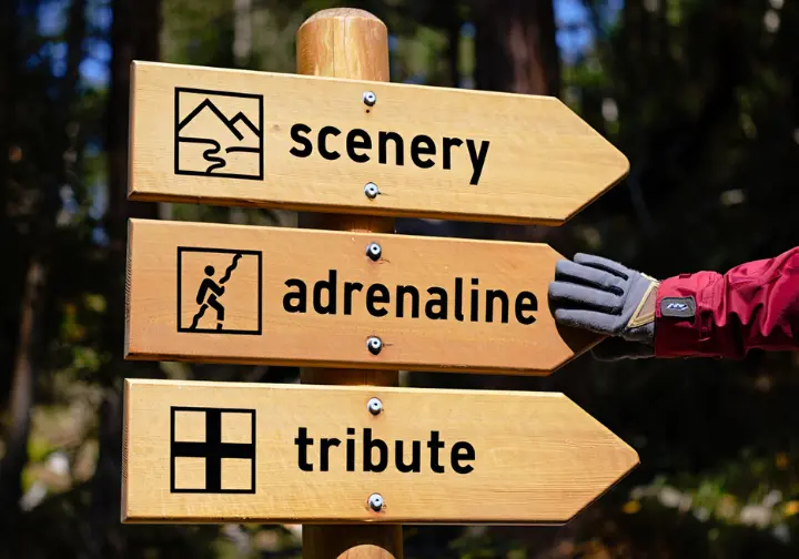
- Quick-Selector: Find Your Storm King Adventure in 60 Seconds
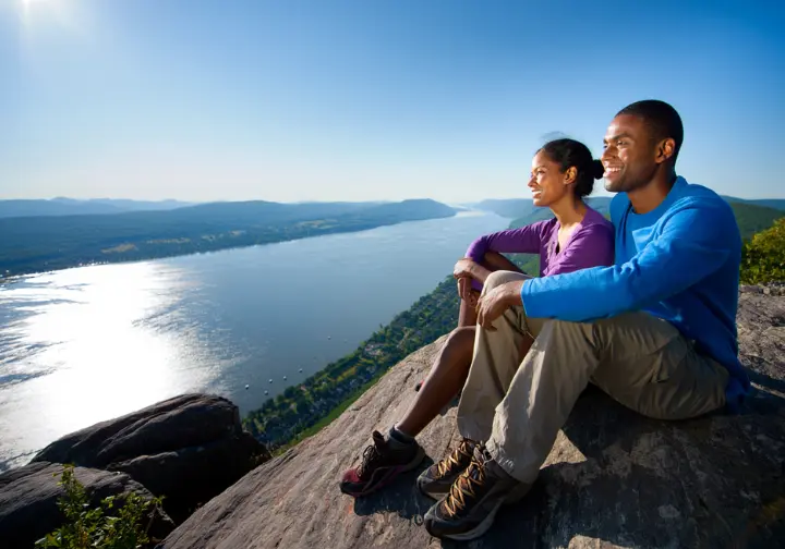
- The Hudson Valley Classic: Hiking Storm King Mountain, NY
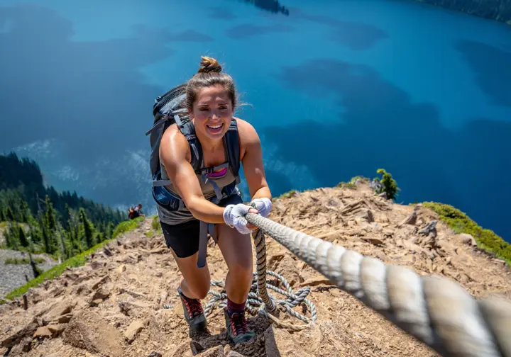
- The Adrenaline Rush: Hiking Mount Storm King, WA
- A Hike of Tribute: The Storm King Mountain Memorial Trail, CO
- Head-to-Head: Choosing Your Storm King Adventure
- Find Your Perfect Storm King Adventure
- Frequently Asked Questions about Hiking Storm King Mountain
A simple search to plan a hike storm king mountain trip presents a geographical puzzle. The query doesn’t point to a single peak, but to at least three distinct and legendary mountains spread across the United States. This ambiguity is the central challenge for any adventurer, but it’s a challenge this guide is designed to solve. We will serve as your definitive resource, resolving the confusion by offering a comprehensive analysis of each trail.
This is not just about telling the mountains apart. It’s about providing the detailed intelligence you need to select the adventure that perfectly aligns with your goals, skill level, and location. We will dissect the logistics, difficulty, and unique identity of each peak—from a Hudson Valley classic in New York, to an adrenaline-fueled climb in Washington’s Olympic National Park, and finally, a somber memorial trail in Colorado. Follow along to find your correct Storm King hike.
Quick-Selector: Find Your Storm King Adventure in 60 Seconds

Get on the right path immediately by choosing your hiking style below. Identify your core motivation for this hiking trip, and jump directly to the detailed analysis that’s right for you.
- For the Classic Scenery Seeker (New York): Your goal is to experience panoramic Hudson River views that inspired 19th-century painters. You want a moderately challenging hike with rewarding rock scrambles, all within an ideal day trip from the New York City area. Head to the New York section.
- For the Adrenaline & Photography Junkie (Washington): Your primary objective is to capture that heart-pounding, social-media-famous photograph while perched high above a stunning glacial lake crescent. You are physically prepared to tackle a steep, grueling climb that culminates in unmaintained rope sections. Jump to the Washington guide for details.
- For the Reflective Hiker (Colorado): Your intention is to undertake a hike with profound meaning. You are seeking a challenging mountain trail that serves as a solemn tribute to fallen heroes and offers a beautiful, reflective experience in the Colorado Rockies. The Colorado guide has the information you need.
The Hudson Valley Classic: Hiking Storm King Mountain, NY
Explore the quintessential Hudson Valley day hike at Storm King Mountain in New York. We’ll cover its rich history, trail stats, critical navigation details, and the unique logistical challenges you need to know before you go.
At-a-Glance: Storm King (NY) Trail Stats
A clear, factual overview is essential for any hiker in the initial planning stages. The table below consolidates key data from park authorities and experienced trail guides, providing a reliable snapshot of what to expect on the Storm King Mountain Loop. This allows for a quick assessment of the hike’s demands and suitability. For more, you can always check the official details from Storm King State Park and learn about the conservation efforts by Palisades Parks Conservancy that protect this area. Because this trail is a popular outing for first time hikers, reviewing some essential tips for beginner hikers is a great way to prepare.
| Feature | Details |
|---|---|
| Location | Cornwall-on-Hudson, NY; Storm King State Park |
| Main Loop Distance | ~2.4 – 3.6 miles (variable based on route) |
| Elevation Gain | ~1,100 feet |
| Difficulty | Moderate to Hard (due to steep initial climb and rock scrambles) |
| Estimated Time | 2 – 4 hours |
| Key Features | Panoramic Hudson River views, rock scrambles, historic ruins nearby |
| Dog-Friendly | Yes, on a leash no longer than 6 feet |
| Fees/Passes | None |
| Best For | Day hikers, photographers, history buffs, those seeking a classic Hudson Valley challenge |
Detailed Trail Guide: Navigating the Loops
The Storm King State Park trails form a network of intersecting, color-blazed paths. To avoid common navigational errors, it’s best to consult the official park trail map and follow these step-by-step trail directions for the most popular route: the Butter Hill Trail Loop. This loop starts at the main Route 9W trailhead. Face the woods and locate the Orange-blazed Butter Hill Trail on your left, which begins its steep climb immediately over rocky terrain.
The most common point of error occurs after this strenuous ascent, where the Orange trail ends at a T-intersection. To continue the loop correctly, you must turn RIGHT onto the combined Blue-blazed Howell Trail and Yellow-blazed Stillman Trail. Continuing on this rocky path leads to the summit of Butter Hill, the first major viewpoint and the highest point on the mountain. From there, the trail meanders across the ridge toward the main summit and the ultimate reward: an open, rocky field affectionately dubbed the “money spot.” This vantage point offers the most iconic panoramic views of Newburgh Bay and Bannerman’s Castle. For those who enjoy this kind of rocky terrain, the nearby challenging scrambles of Bear Mountain offer a similar thrill.
To complete the loop and descend, you must navigate another key junction shortly after the “money spot.” The Blue/Yellow trail takes a sharp U-turn to the left. Instead of following it, proceed straight to begin your descent on the White-blazed Bypass Trail, which leads all the way back to the starting parking area.
Logistics & Planning: Your Storm King (NY) Checklist
The primary Storm King Mountain trailhead is a small scenic pull-off on the Storm King Highway (U.S. Route 9W) that gets extremely crowded, especially on weekends. Arriving before 8:30 AM is strongly recommended to secure one of the limited spots. A much smaller alternative lot is available at the Esty & Hellie Stowell Trailhead further north.
A critical logistical hurdle is that the main parking lot can only be accessed from the northbound lane of Route 9W. The divided highway makes a left turn from the southbound lane both illegal and extremely dangerous.
To access the lot from the north, you must continue south for three miles past the trailhead to the Route 218 interchange, circle back onto Route 9W North, and then legally enter the parking area on your right. Understanding this nuance in advance will save you significant frustration.
The Storm King State Park is intentionally undeveloped, which means there are no bathrooms, no drinking water, and no trash receptacles. You must pack in all your water and pack out all your trash in your backpack. Given these limited facilities and the potential challenges on the trail, self-sufficiency is paramount, so be sure you are packing the Ten Essentials. Finally, be aware that hunting is permitted on the west side of Route 9W in certain seasons, so wearing bright colors is advisable for safety.
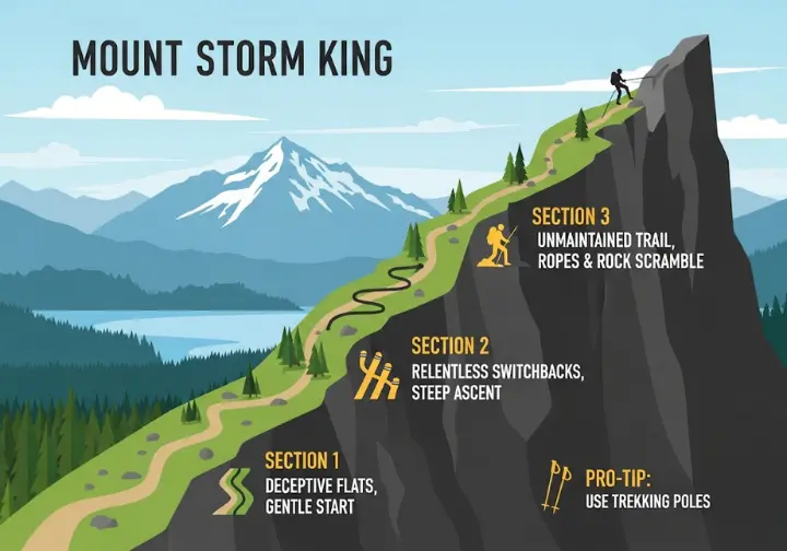
The Adrenaline Rush: Hiking Mount Storm King, WA
Prepare for the notorious and physically demanding Storm King hike in Washington’s Olympic National Park. The trail is famous for its unrelenting steepness, the infamous unmaintained rope section, and the breathtaking views that reward those who are prepared for the challenge.
At-a-Glance: Mount Storm King (WA) Trail Stats
The vital statistics for this hike immediately convey its challenging nature. The significant elevation gain packed into a relatively short distance is the defining characteristic that demands respect and preparation. The following table provides a consolidated overview of what to expect, and you can find additional official trail details from the National Park Service on their website.
| Feature | Details |
|---|---|
| Location | Olympic National Park, WA; South shore of Lake Crescent |
| Trailhead | Storm King Ranger Station / Marymere Falls Trailhead |
| Distance | ~4.1 miles round-trip (out-and-back) |
| Elevation Gain | ~2,100 feet |
| Difficulty | Hard / Strenuous / Difficult |
| Estimated Time | 3 – 5 hours |
| Key Challenge | Steep, continuous ascent and an unmaintained, exposed final section requiring the use of ropes. |
| Dog-Friendly | NO. Pets are strictly prohibited. |
| Fees/Passes | National Park Pass required (e.g., America the Beautiful) |
| Best For | Experienced, fit hikers; adventure seekers; photographers; those comfortable with heights and exposure. |
Detailed Trail Guide: From Deceptive Flats to Exposed Heights
The Storm King hiking trail to the summit is a journey in three distinct parts. The hike begins at the Storm King Ranger Station, sharing a trailhead with the much easier Marymere Falls Nature Trail. This first half-mile is deceptively gentle, a wide, flat path that can lull you into a false sense of security before the real work begins. The turnoff for Mount Storm King is clearly marked, and from this point, the trail’s character changes instantly. It narrows and begins a relentless, steep ascent via a series of switchbacks that will ignite a slow burn in your thighs.
After a significant amount of climbing, you will reach a sign that explicitly states “end of maintained trail.” This marks the crux of the entire hike—the beginning of the unmaintained climber’s path that leads to the summit.
[PRO-TIP] The ropes on this section are not an official feature installed or maintained by the National Park Service. They have been placed by other hikers, and their condition can be questionable. Relying on them is done entirely at your own risk.
Before proceeding, you must honestly assess your own skill level, your comfort with heights, and the current trail conditions. The terrain here is exposed, with loose dirt and rock. For those who continue, a final, exposed rock scramble over a boulder field is required to reach the ultimate viewpoint. For the punishing downhill section, trekking poles are invaluable to help save your knees. To see just how challenging this section is, it’s worth checking for recent trail reports from the Washington Trails Association before your trip.
Logistics & Planning: Your Mount Storm King (WA) Checklist
The trailhead is located on the south shore of Lake Crescent in Olympic National Park. From Port Angeles, drive approximately 20 miles west on U.S. Highway 101 to the parking area at milepost 228. Since the trail is within the park, you must display a valid National Park Pass. The lot is shared with other visitors and fills quickly, so an early start is highly recommended. You can find more details from The Mountaineers on their route descriptions.
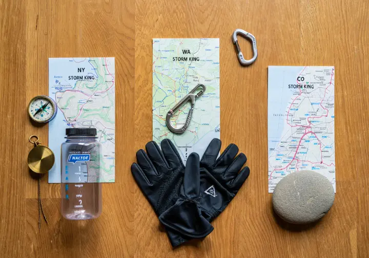
A successful and safe hike today has specific and non-negotiable requirements. First, there is a strict NO DOGS regulation on this trail. Second, the gear you bring is critical. Sturdy hiking boots with excellent grip are absolutely essential; regular sneakers are not adequate for the slippery, loose terrain of the upper sections. A pair of gloves with a good grip is highly recommended to protect your hands on the rope sections, and hiking poles will be a huge asset on the steep descent. Finally, pack layers, as the weather can change quickly at the exposed summit.
Your Mount Storm King Planning Tool
This hike demands respect and preparation. Use our interactive checklist to cover all your bases, from essential logistics to critical gear for the ropes section. Check items off as you plan and download a PDF copy.
A Hike of Tribute: The Storm King Mountain Memorial Trail, CO
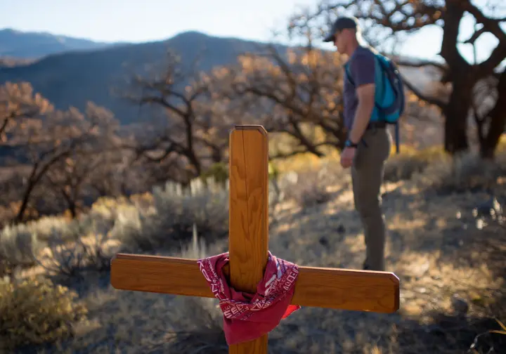
The Storm King Mountain Memorial Trail in Colorado offers a journey of remembrance and a solemn tribute to the 14 wildland firefighters who tragically lost their lives battling the South Canyon Fire on July 6, 1994.
The Story of the South Canyon Fire: July 6, 1994
To hike this memorial trail is to walk through a natural landscape defined by history. The tragedy began with a lightning strike during a period of severe drought and record-high temperatures. On the afternoon of July 6, 1994, elite firefighting crews—including smokejumpers and the Prineville Interagency Hotshots—were on the mountain working to contain the blaze. According to the official report on the South Canyon Fire, a dry cold front moved rapidly into the area, causing the fire to make an explosive run up a steep drainage.
A wall of flame rushed up the hill toward the firefighters. Twelve were unable to outrun the flames and perished. Two additional helitack crew members on the ridgetop also died as they tried to escape. In total, 14 firefighters lost their lives: Kathi Beck, Tamera Bickett, Scott Blecha, Levi Brinkley, Douglas Dunbar, Terri Hagen, Bonnie Holtby, Rob Johnson, and Jon Kelso of the Prineville Hotshots; and Don Mackey, Roger Roth, Jim Thrash, Richard Tyler, and Robert Weaver. These were powerful stories of resilience and self-discovery cut tragically short.
Detailed Trail Guide: Walking in Their Footsteps
The design of the trail is integral to its purpose as a memorial. It was intentionally left rugged and primitive to help visitors comprehend the near-impossible conditions in which the firefighters had to work. The difficulty is not a flaw; it is a feature meant to evoke empathy and respect. You can view the memorial trail map from the Bureau of Land Management to plan your visit.
The journey can be understood in two parts. The first is a steep, constructed trail that climbs to an observation point, with interpretive signs explaining the events from a distance. From there, the trail’s character changes. A more primitive path drops into a ravine and then climbs up the other side to the actual memorial sites where the firefighters fell. This section is the emotional core of this fascinating hike. Here you will find individual crosses, which have become deeply personal shrines adorned with faded T-shirts, crew patches, and other mementos. It is critical to tread lightly on what is considered hallowed ground and treat the area with the utmost respect.
Head-to-Head: Choosing Your Storm King Adventure
To make a final, informed decision, use the direct, comparative framework below to evaluate the three Storm King hikes. It synthesizes the data from each trail to directly address the central ambiguity of the original search query, helping you choose the perfect hike for you. For hikers who enjoy this process, our advice on choosing between iconic hiking destinations offers a similar approach for international trails.
The Ultimate Storm King Comparison Matrix
Use the matrix below as the ultimate answer engine. It allows for a quick, side-by-side evaluation of the three trails based on the most critical factors for a hiker’s decision-making process.
Comparing the “Storm Kings” of the USA
A detailed look at three distinct natural attractions sharing a powerful name, each offering a unique experience.
Location & Appeal
Cornwall-on-Hudson, NY. Classic Scenery & History.
Key Challenge & View
Steep initial climb, rock scrambles. Signature View: Hudson River, Bannerman’s Castle.
Distance & Gain
~3.6 mi loop. Elevation Gain: ~1,100 ft.
Access
Dog-Friendly: Yes, on leash. Pass/Fee: None.
Location & Appeal
Olympic National Park, WA. Adrenaline & Iconic Photo.
Key Challenge & View
Grueling ascent, exposed/unmaintained ropes. Signature View: Lake Crescent from a rocky perch.
Distance & Gain
~4.1 mi out-and-back. Elevation Gain: ~2,100 ft.
Access
Dog-Friendly: NO. Pass/Fee: National Park Pass.
Location & Appeal
Glenwood Springs, CO. Memorial & Tribute.
Key Challenge & View
Emotionally taxing, intentionally rugged terrain. Signature View: Overlook of the South Canyon fire area.
Distance & Gain
~4.2 mi out-and-back. Elevation Gain: ~700+ ft.
Access
Dog-Friendly: Yes. Pass/Fee: None.
Find Your Perfect Storm King Adventure
The name “Storm King” signifies not one, but three distinct and powerful hiking experiences across America. From the historic, scenic vistas of New York’s Hudson Highlands to the adrenaline-pumping, high-risk challenge in Washington’s Olympic National Park, and the deeply moving, reflective tribute in the mountains of Colorado, each trail offers its own unique journey. By understanding their core differences in character, difficulty, and purpose, every hiker can find the adventure they seek. We encourage you to explore these legendary landscapes safely, responsibly, and with a full understanding of the path you choose to take.
Share your Storm King adventure—or which one you plan to hike—in the comments below!
Frequently Asked Questions about Hiking Storm King Mountain
How difficult is the Storm King hike?
The difficulty varies greatly by location. The Storm King hike NY is considered moderate-to-hard with steep ascents. The Washington hike is extremely strenuous and technical due to the rope section. The Colorado memorial trail is physically and emotionally challenging, with intentionally rugged terrain.
How long does it take to hike Storm King?
Estimated times vary. The New York loop typically takes 2-4 hours. The Washington out-and-back is estimated at 3-5 hours. The Colorado memorial trail also takes about 2-4 hours. These are just estimates and can change based on your fitness and trail conditions.
Do you need a pass to hike Storm King?
It depends on the location. The hikes in New York and Colorado are free to access. However, the hike in Washington is inside Olympic National Park and requires a valid National Park Pass or a federal interagency pass to be displayed in your vehicle.
Can you bring a dog on the Storm King hike?
Yes, you can bring a dog on the trails in New York (on leash) and Colorado. However, there is a strict NO PETS policy on the Mount Storm King trail within Washington’s Olympic National Park to ensure safety and protect the environment.
Risk Disclaimer: Hiking, trekking, backpacking, and all related outdoor activities involve inherent risks which may result in serious injury, illness, or death. The information provided on The Hiking Tribe is for educational and informational purposes only. While we strive for accuracy, information on trails, gear, techniques, and safety is not a substitute for your own best judgment and thorough preparation. Trail conditions, weather, and other environmental factors change rapidly and may differ from what is described on this site. Always check with official sources like park services for the most current alerts and conditions. Never undertake a hike beyond your abilities and always be prepared for the unexpected. By using this website, you agree that you are solely responsible for your own safety. Any reliance you place on our content is strictly at your own risk, and you assume all liability for your actions and decisions in the outdoors. The Hiking Tribe and its authors will not be held liable for any injury, damage, or loss sustained in connection with the use of the information herein.
Affiliate Disclosure: We are a participant in the Amazon Services LLC Associates Program, an affiliate advertising program designed to provide a means for us to earn advertising fees by advertising and linking to Amazon.com. As an Amazon Associate, we earn from qualifying purchases. We also participate in other affiliate programs and may receive a commission on products purchased through our links, at no extra cost to you. Additional terms are found in the terms of service.


